Wed, 31 Aug 2016

Monitoring Vancouver Island Estuaries

Installing-SET-Platform_Cluxewe_July2016

Thanks to Karen Barry from the VICLMP program for sending us this project update!

The Vancouver Island Conservation Land Management Program* has initiated a long term monitoring program to assess the health of estuaries and salt marshes on the east coast of Vancouver Island with support from HCTF and other partners. The goal of this monitoring program is to ensure that conservation lands provide high quality, accessible habitat for fish and wildlife, and to identify conservation concerns resulting from threats such as sea level rise, invasive species, or other human-induced changes. By implementing a standardized monitoring program, we can ensure investments made towards protection of sensitive estuaries are secured for the long-term.

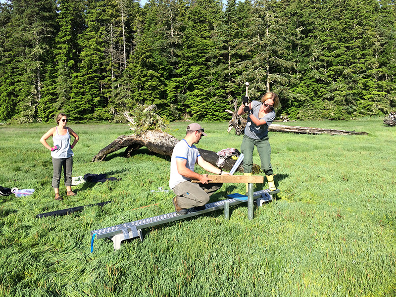
To determine the resiliency of coastal estuaries to sea level rise, we are installing Surface Elevation Tables (SET) platforms in several estuaries this summer, including Quatse River, Cluxewe River, Salmon River, Englishman River, Nanaimo River and Cowichan River estuaries. These devices allow us to see how salt marshes and estuaries are changing over time, by measuring changes in elevation of the substrate. The SET consists of an aluminum platform that is permanently installed in the estuary and anchored to prevent any movement. To take measurements, a specialized reader arm is brought out to the estuary, mounted to the platform and several rods are lowered from the arm onto the surface. Because the location and orientation of the device is fixed during sampling, we can record highly precise elevation measurements. Annual fine-scale readings are compared over time to see how much deposition or erosion is occurring.

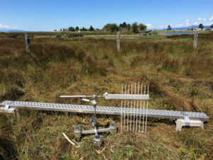
When measurements indicate a positive change in elevation, it means that sediment is being deposited, the plants are healthy and stabilizing the sediments, and the underlying marsh soils are getting thicker (accreting). This is a natural process in healthy salt marshes which increases the resiliency of estuaries to rising sea levels. In contrast, negative readings indicate decreasing elevation which means that the marsh surface is sinking (subsiding) or eroding. When the rate of sediment deposition (or accretion) does not match or exceed the rate of subsidence or sea level rise, the salt marsh can eventually “drown” meaning that it becomes sub-tidal. This can result in significant habitat changes for fish and wildlife; for example, vegetated salt marshes can become unvegetated mud flats.

Results from our SET measurements will provide important information about local ecosystem change that can help inform management. Specifically, we will gain a better understanding of whether our estuaries are resilient over the long term, what habitats may be most vulnerable to sea level rise, and what potential restoration actions may be warranted to maintain or improve fish and wildlife habitat.

* The Vancouver Island Conservation Land Management Program (VICLMP) is a strategic partnership program with Environment Canada-Canadian Wildlife Service, the Ministry of Forests, Lands and Natural Resource Operations, Ducks Unlimited Canada, The Nature Trust of British Columbia, and funding from Habitat Conservation Trust Foundation. VICLMP’s work focuses on managing over 100 conservation areas on Vancouver Island and the central and north coasts.

Wed, 24 Aug 2016
Tags: Fisheries

Rock Breaking Begins at Seymour Slide Site

Aerial photo of the Seymour River rockslide. Photo credit: Taylor Ramsden

The Seymour Salmonid Society and its partners are pleased to announce that work has begun to restore fish migration around the rockslide debris that has blocked the Seymour River for over 20 months.

On December 7, 2014, an estimated 50 000 cubic meters of rock fell into the lower canyon of the Seymour River following a catastrophic slope failure. The slide debris blocked the river and caused upstream water levels to rise by almost 10 meters. Acoustic and radio tagging studies have confirmed that the blockage has prevented both adult and juvenile salmon from accessing their primary spawning habitats upstream, creating serious concerns about the survival of salmonids on the Seymour. The river is home to unique runs of wild summer and winter steelhead, currently listed by the Province as a conservation concern. Coho, chinook, chum and pink salmon also use the river as spawning and rearing habitat.


Shaun Hollingsworth, President of the Seymour Salmonid Society, emphasized the effects the blockage will have on the river’s fish populations if left unmitigated: “If these fish remain cut off from their spawning habitats, the Seymour’s wild steelhead and coho populations will likely be reduced to mere remnants within five years. The summer-run steelhead may ultimately disappear,” says Hollingsworth. “We must do whatever needs to be done to save these fish.”

Fisheries and Oceans Canada’s Salmonid Enhancement Program, the BC Ministry of Forests, Lands and Natural Resource Operations, Metro Vancouver, the District of North Vancouver, Squamish Nation and Tsleil-Waututh Nation Bands have all agreed in principle to begin re-shaping the slide using scaling crews, low-velocity rock breaking, and river flows as part of a shared vision to “restore migration conditions for all species that existed before the 2014 rockslide, in a safe and sustainable manner.”

Funding for the reshaping has been provided by the Habitat Conservation Trust Foundation, Freshwater Fisheries Society of BC, the Ministry of Forest, Lands and Natural Resource Operations, Tsleil-Waututh Nation, Squamish Nation, the Recreational Conservation Partnership Program, the Department of fisheries and Oceans, both the District and the City of North Vancouver, Coho Society of BC, Steelhead Society of BC, BC Federation of Drift Fishers, and multiple private donations.

The Seymour Salmonid Society is a community based organization consisting of volunteers whose mission is to enhance Seymour River salmon and educate the public about the importance of the river as a resource for drinking water, wildlife, and the forest. For more information, contact Brian Smith, Seymour Salmonid Society Hatchery Manager on 604 288-0511. To join the community volunteers, or donate, please visit www.seymoursalmon.com


PDF Version of Release

Photos (please contact us for larger versions of these images)


Credit Simon Ager

Credit Taylor Ramsden


An engineer marks drilling locations in preparation for Wednesday's rock breaking on the Seymour River.


Read the story in the North Shore News >>

Sun, 12 Jun 2016

Quesnel Lake Tagging Program Receives Top Honours

HCTF Silver Award winner Lee Wiliston’s project was recently featured in the 2016 Cariboo-Chilcotin Fishing Guide. Angie Mindus, editor of the Williams Lake Tribune, wrote the following article about the Quesnel Lake tagging program, and has kindly agreed to let us republish the story here.


High-Tech Tagging Program Unravels Mysteries of Quesnel Lake


A five-year study examining the effects of angling pressures on resident rainbow, bull and lake trout in Quesnel Lake has netted a prestigious provincial award, accolades from professionals in the field and critical information to ensure the long-term survival of the species.

The Quesnel Lake fish tagging program, which was launched in 2013 in response to public reports of improved fish numbers in the lake and requests to review the restricted fishing regulations, is entering its fourth year and relies on a winning combination of a high tech fish-tracking system and good oldfashioned reporting from anglers.

Lee Williston, study leader and senior fisheries biologist with the Ministry of Forests, Lands and Natural Resource Operations, said he couldn’t be happier with the results.

“The knowledge we have gained over the last three years has really exceeded all our expectations:’ Williston said. “The number one priority is to ensure the long term sustainability of Quesnel Lake trout populations. But we also don’t want to be unnecessarily restrictive. We want people out there fishing and enjoying the resource and the better information we have, the less restrictive we have to be.”

The study has shed some light on critical questions surrounding the different species, such as the species’ mortality rates, use of habitat and sensitivity to angling pressures.

A rainbow trout is fitted with a high-reward floy tag as part of the Quesnel Lake Exploitation Study.To date, about 600 rainbow, bull and lake trout have been equipped with high-reward floy tags and released back into the lake where Williston’s team have placed 30 acoustic receivers at various locations in the 100 kilometre-long, 525-metre deep lake. Of those fish, 250 have also been implanted with acoustic tags. When an acoustic tagged fish travels within approximately 700 metres of a receiver, the unique identification number, date, time, location and depth of the fish is recorded.

“The technology available is incredible,” he said.

The method has revealed some fascinating preliminary data about the genetically unique rainbows, which are the main focus of the study, confirming that the fish will travel from the tip of the west arm at Likely to the end of the east arm in as fast as a week searching for food.

“What we’re finding is they are using the entire lake, which is amazing. You have a 50 centimetre fish covering a 100 kilometres — that’s impressive:’

It has also confirmed what area residents were reporting – that the large, genetically unique Quesnel Lake rainbows were making a comeback.

“For the most part, things look really positive. The size and condition of the rainbows has been very good. Their numbers have also improved in recent years, largely due to the increase of Kokanee, their main food source. But more study is needed to fully understand the exploitation rate of rainbows,” Williston said.

With help from members of the fishing community, who have returned 50 $110 tags on rainbows so far, Williston said they suspect the large rainbows are sensitive to overfishing, due to their aggressive nature.

“They are a large-bodied predator cruising around looking for prey. They need a high-energy food source and they’re very aggressive. This aggressiveness makes them highly catchable which can make it appear as though there are far more fish than there really are.”

Early study results from lake trout, on the other hand, led to the ministry increasing the daily quota of Quesnel Lake lake trout from one to three per day, after it revealed the species has a low exploitation rate.

The study is also providing some information on the lesser known, more illusive bull trout.

“Bull trout are a tough one to put in a box,” he said. “We are learning that there are multiple distinct populations of bull trout that use the Quesnel Lake system.”

Williston said the bull trout, which are strictly a catch and release fishery on Quesnel Lake, are a sensitive, cold water fish that require steep, cool streams to live in for the first one to three years of its life. He said the bull trout seem be closely linked to the salmon as a critical food source and have limited habitat in Quesnel Lake, which naturally limits their numbers.

He noted few systems have rainbow, bull trout and lake trout co-existing.

“They’ve carved out at niche at Quesnel Lake.” Williston said angler participation has been essential to the success of the program, set to wrap up next year, and determines critical estimates on exploitation rates which in turn will help set regulations.

“The public response has been excellent. People are genuinely interested in not only the study, but in Quesnel Lake and the health of the fish in general and we’re very thankful for their help.”

The Quesnel Lake Tagging Program was made possible through funding provided by the Habitat Conservation Trust Fund (HCTF), which is largely supported by licensing fees collected from anglers, trappers, hunters and guide outfitters.

This year HCTF recognized Williston and his team with its prestigious Silver Award for outstanding contribution to conservation in B.C.

HCTF CEO Brian Springinotic said Williston’s proposal, which beat out 200 other applicants, was well thought out with clearly stated objectives that included community involvement.

“He’s done a great job in reaching out to the community to explain what work is being done out there and that’s really important. People want to know what is happening in their areas. They are genuinely interested in the study and the resource,” Springinotic said, noting HCTF recognized the project’s value early on.

“Quesnel Lake is this iconic lake in B.C. – it’s very large, very deep and it has a collection of very large, important species of fish.”


Thu, 19 May 2016
Tags: Fisheries

Kids Take Part in Moberly Lake Trout Conservation Efforts

HCTF Board Chair Ross Peck helps out with the lake trout release at Moberly Lake.

At Moberly Lake last Tuesday, fifty elementary students (and HCTF Chair Ross Peck) helped government staff release 8,000 juvenile lake trout as part of an ongoing effort to rebuild a population that has come dangerously close to extinction.

When the Province began the Moberly Lake rehabilitation program back in 2010, there were less than 400 trout in the lake. Their extreme drop in numbers was thought to be caused by a combination of overfishing and competition or predation from other fish species. Historically, Moberly Lake’s lake trout were an important part of the local First Nations fishery and a favourite of local anglers, but the lake has been closed to all trout fishing since 2002, and is closed to all fishing from September 15 to October 31 to protect lake trout during their spawning season.

Last Tuesday’s lake trout release was the third release of the rehabilitation program, for a total of 36,000 released fish. The Ministry is hopeful these releases will aid in re-establishing a stable lake trout population on Moberly Lake. Over the past four years, the Habitat Conservation Trust Foundation has provided funding to the Ministry to evaluate the effectiveness of their lake trout recovery program. As well as continuing to monitor the total number of lake trout in Moberly, staff are also tracking the survival, growth, fitness and reproduction rates of the stocked juvenile lake trout. The information collected will help detect shifts in the Moberly Lake fish community and hopefully identify why survival of juveniles is low, in the hopes that a long-term solution can be found.

Wed, 6 Jan 2016

15 Years of Investments in BC’s Premier Angling Streams

QWS report coverBC has a reputation for outstanding freshwater sport fishing, perhaps best exemplified by its world-class angling opportunities for steelhead and other trout on streams. “Quality Waters” is a descriptive term used by fisheries managers and anglers to describe the sum of all Classified Waters (and some non classified waters) that provide the province’s premier stream angling opportunities. Since 1997, HCTF has received and allocated dedicated funding for a variety of Quality Waters projects across BC. We have just released a report summarizing those investments. The report provides a historical perspective of government licence pricing decisions, documents the revenue received and briefly describes project investments made by HCTF on Quality Waters. It also provides a unique resource to help inform new policies and procedures about the involvement of HCTF in the evolution of the broader provincial Quality Waters Strategy. You can view the report here.

Tue, 22 Sep 2015

Penticton Creek Completion Achieves Major Milestone in Restoration Project

A major milestone has been achieved in Penticton Creek restoration this week, as the showcase project construction and the creek side planting program have been completed.

“We have already had several reports of Kokanee navigating upstream with ease along the new creek bed. The difference you can see in Penticton Creek before and after the restoration project is amazing,” said Penticton Mayor Andrew Jakubeit. “The City of Penticton is grateful for the tremendous support of our partners in this initiative, including the Habitat Conservation Trust Foundation – their financial support has really made this project possible.”


The restoration of Penticton Creek was identified during the 2012 Downtown Plan consultations as among the top priorities for residents and businesses, and has been identified among the long-term Downtown 101 action items to be completed for revitalizing the downtown.

Construction started Aug. 4, a historic event that saw concrete pulled out of Penticton Creek for the first time in over 50 years. The showcase project was designed to demonstrate what creek restoration can look like, with the goal of restoring fish habitat, maintaining flood protection and stabilizing creek banks.

The Habitat Conservation Trust Foundation (HCTF), provided significant funding for both the planning and construction phases of this project.

HCTF CEO Brian Springinotic says the Foundation’s support of the restoration of Penticton Creek aligns with its previous million-dollar investment in a recovery plan for Okanagan Lake’s kokanee. “The Okanagan Lake Action Plan made strong recommendations to improve spawning habitat in historic kokanee streams such as Penticton Creek,” said Springinotic. “This restoration project will help deliver on those recommendations.”

This sample project includes a small section (80 metres) of Penticton Creek upstream from the Ellis Street Bridge. This site was chosen to substantially improve fish habitat, as well as address severe maintenance issues while showing the community the transformation in a visible area.

Designing a creek bed that safely moves water through the area is important for flood protection, and this was considered in the balance with elements that create good fish habitat – rearing areas (resting, hiding and feeding zones), spawning grounds, and minimizing velocity and elevation barriers to migration. Fish species that stand to benefit from improved habitat include Kokanee and Rainbow Trout.

The public is invited to check out the completed Penticton Creek restoration showcase project. The Ellis Street bridge offers an excellent vantage point. For information, visit www.penticton.ca/downtown.

The Penticton Creek restoration project would not have happened without the funding and contributions of several agencies: Habitat Conservation Trust Foundation, Fisheries and Oceans Canada, Freshwater Fisheries Society of B.C., Province of B.C., Penticton Indian Band, South Okanagan Similkameen Conservation Program, Okanagan Nation Alliance, TD Friends of the Environment Foundation, Penticton Flyfishers and Downtown Penticton Association.