Tue, 20 Jan 2026

Reflecting on the Northern B.C. Ecosystem Restoration CoP

Reflecting on the Northern B.C. Ecosystem Restoration Community of Practice (CoP) 2025 Annual Workshop + Conference

Contributed by Mae Whyte, SERNbc

Uda dune Baiyoh (House of Ancestors), Prince George, B.C. and online
November 25-27, 2025

From caribou ranges to wetlands and wildfire-scarred forests, the collective will to address ecosystem degradation is enormous. Despite winter weather and illness limiting attendance, more than 120 restoration practitioners gathered online and in-person to build, develop, and strengthen our community of practice.

People from multiple sectors with wide-ranging experiences met over two-and-a-half days. The energy in the room was unmistakable and infectious. The workshop brought together voices from across British Columbia and beyond, all united by a shared goal: healing lands, waters, and relationships.

Speakers shared lessons learned from real projects, while attendees compared notes, debated ideas, and built new connections. Informal meet-ups, shared meals, and side events helped turn a group of professionals into a genuine community. We brainstormed and crowdsourced ways to solve our restoration challenges while enjoying some of the best food in the Omineca!

By the time people headed home, it was clear that the November 2025 workshop was not just a conference—it was a turning point. New working groups, webinars, and online hubs are already being built to keep the momentum going through 2026 and beyond.

Stay connected with the CoP:

The Community of Practice Organizing Team is comprised of: Society for Ecosystem Restoration in Northern BC (SERNbc), the Habitat Conservation Trust Foundation (HCTF) via the Caribou Habitat Restoration Fund (CHRF), Fish & Wildlife Compensation Program (FWCP), and the BC Wildlife Federation (BCWF).

Wed, 4 Oct 2023

Project Profile & Lessons Learned: Goldway Road Restoration

Goldway Road Restoration - Chu Cho Environmental LLP

In 2018 Chu Cho Environmental identified several candidate roadways for restoration within the Chase caribou herd range with input from forest licensees, caribou biologists, and Tsay Keh Dene Nation. In total, Chu Cho Environmental and Tsay Keh Dene Nation have now completed restoration work on 3 roads within the Chase caribou herd boundary since 2019. Collectively, these projects have been a part of the larger Chase Caribou Road Restoration Program (CCRRP), with the Goldway road being the most recent restoration project.

Planted Seedling – Chu Cho Environmental LLP

Sean Rapai of Chu Cho Environmental shares the challenges and lessons learned on this project including those around permitting, post-treatment monitoring and longer-term considerations.

Permitting: The historical presence of anadromous salmon in Johanson Creek, combined with the presence of bull trout and steelhead trout impacted the window for fording Johanson Creek with an excavator. It was necessary to submit an application to Fisheries and Oceans Canada (DFO) with the proposed plan and timing window of the work. The Letter of Advice was eventually secured which indicated work could proceed as planned. Best practices were outlined as well as recommendations for the fording process. This proved challenging, but the project did receive approval from DFO.

Monitoring: Ecological restoration treatments could take five or more years to begin to show results. With monitoring, we are attempting to answer a long-term set of questions and return to the site in the years immediately following restoration. Monitoring can be very costly as assessing control treatments is often restricted to the use of a helicopter. Chu Cho Environmental investigated the feasibility of using remotely piloted aircrafts (drones) as a more cost-effective method of monitoring restored areas in the short-term. This method was explored for monitoring remote roadways and restored areas.

Drone-based monitoring: Based on recommendations from 2021, Chu Cho Environmental deployed drone-based remote-sensing surveys to monitor vegetation using derived NDVI indices. Data was collected to a resolution of 1 m2 and can be paired with future surveys to track vegetation establishment and growth along large stretches of the road. While the use of a drone as a monitoring tool in this restoration program is in the preliminary stages, the ease of data collection and results suggest this is a viable means of evaluating vegetation indices on pre and post restoration roadways.

Stability of ecological restoration treatments: Year one monitoring of the ecological restoration techniques used in the project showed strong persistence of these treatments. The rough-and-loose soil contouring was stable, intact, and holding water, and planted seedlings had a high survival rate.

Recontouring inhibits human access: Areas recontoured with the rough-and-loose treatment had the least evidence of use by humans, including those on horseback. Aggressive recontouring of roads at strategic locations may be considered a viable tool to discourage trail usage and eliminate all-terrain vehicle use.

Snow alters access by motorized vehicles: Snowmobile use of the road was observed when the snow had accumulated above restoration efforts (i.e., above height of felled trees and mounds). While the effect of such anthropogenic use has yet to be studied here, considerations may be required for future restoration efforts or access management restrictions on snowmobile use.

Functional restoration: Felled trees were intact, and it was observed that larger diameter trees felled from steep cut banks created better movement barriers. Conversely, smaller diameter trees felled for functional restoration did not provide as good of a visual and physical barrier and is suggested that when small diameter trees are the only available source, they are felled in stacks. High survival of planted seedlings, following mechanical site preparation, suggests that tree planting is likely to provide visual screening over the long term, and may represent a more effective long term means of functionally restoring these roadways.

The Goldway road lies within the range of the Chase caribou (Rangifer tarandus caribou) herd, which is considered by the federal government of Canada to be part of the Northern group of the Southern Mountain population of Woodland caribou. This herd is listed as threatened on Schedule 1 of the Species At Risk Act (SARA).

Tue, 27 Jun 2023

Project Profile & Lessons Learned: Tweedsmuir Caribou Winter Range – Chelaslie Road Restoration

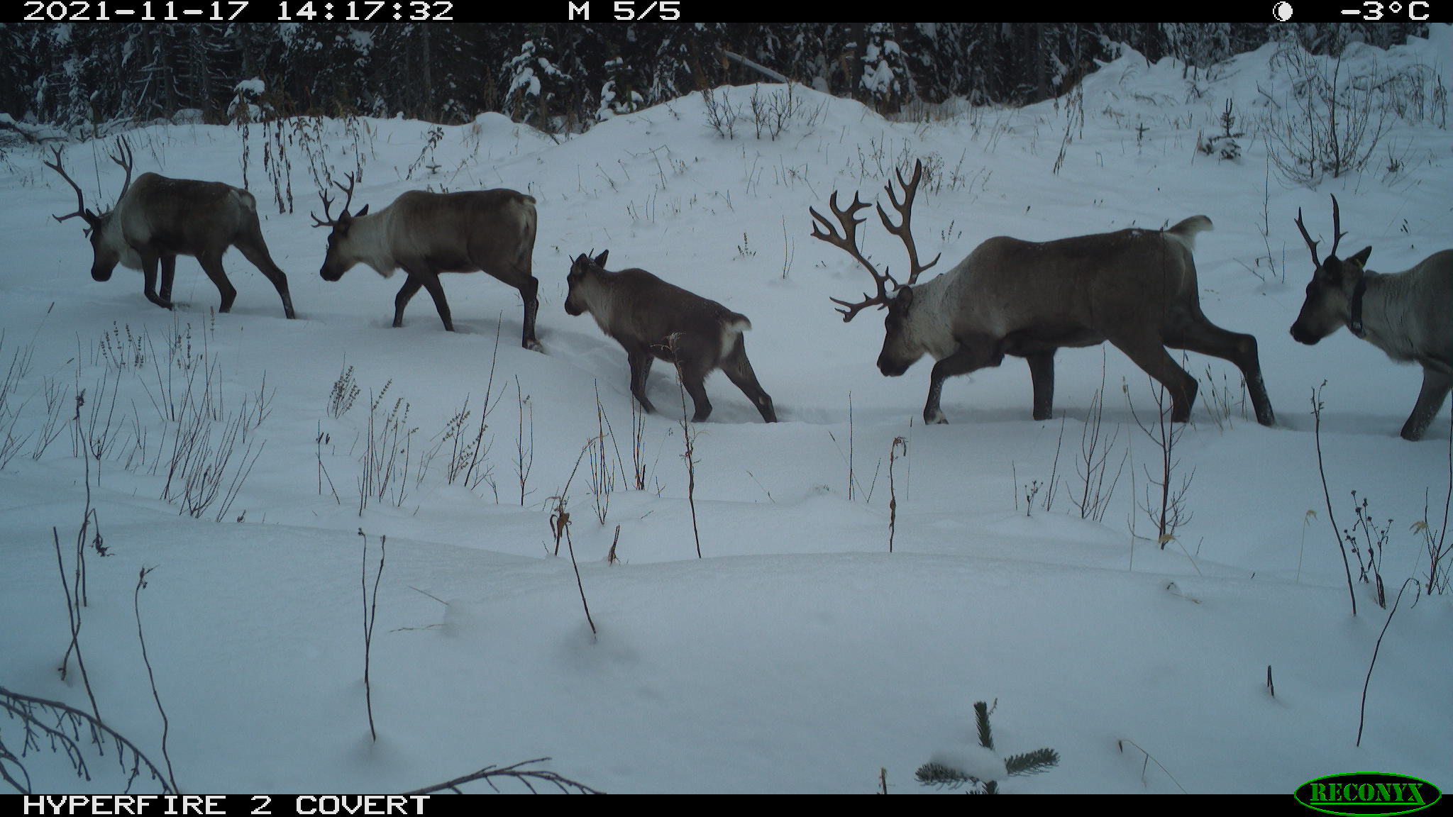
Group of caribou detected on Reconyx remote camera.

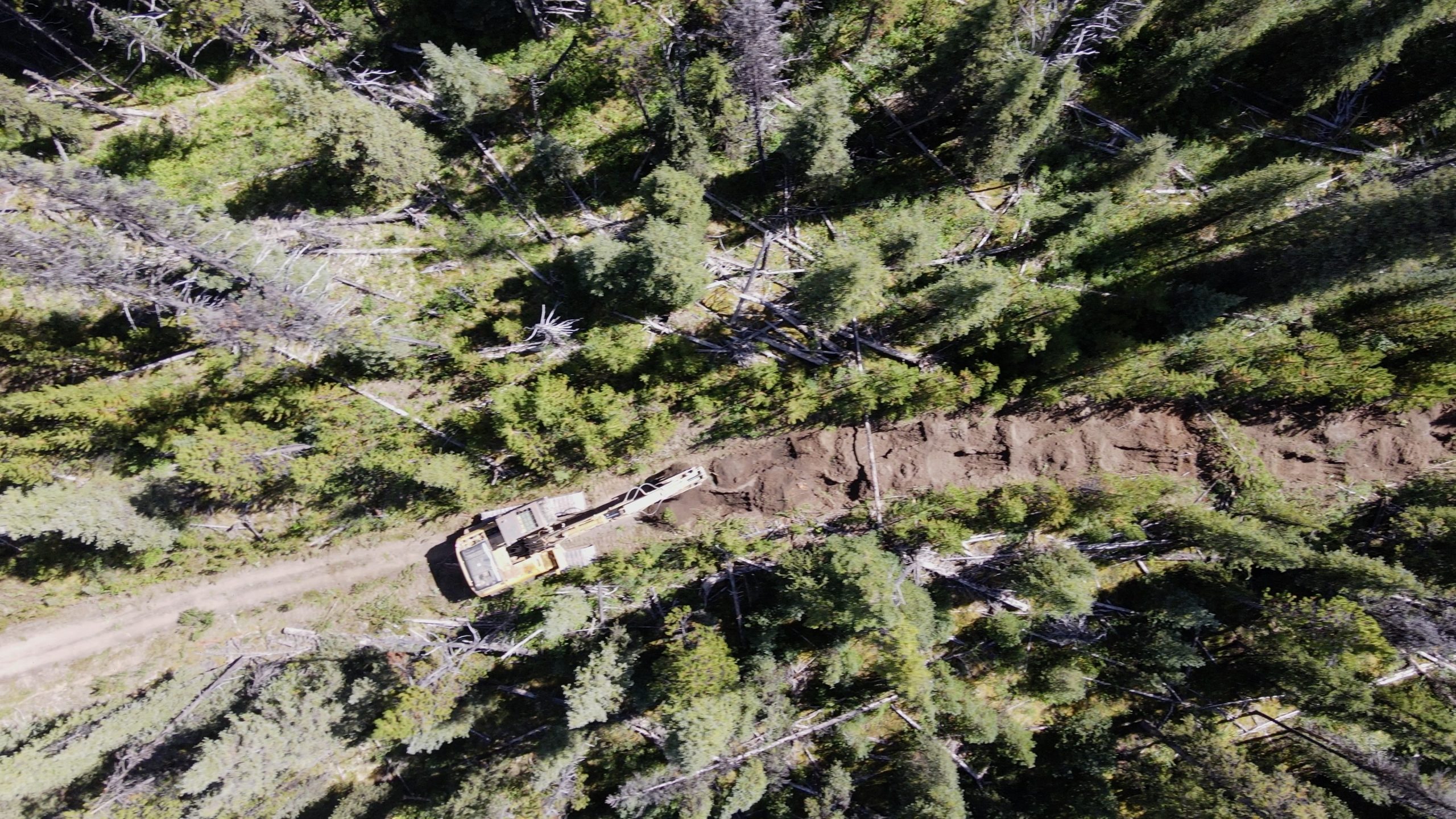
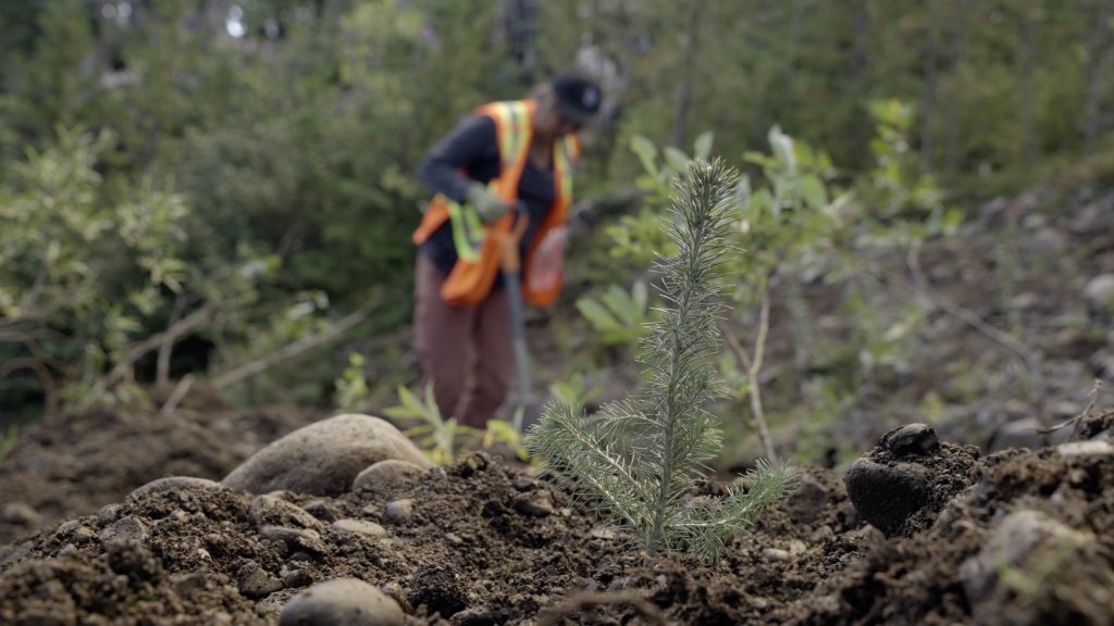
Directly east of Tweedsmuir Park, there is an area caribou utilize as their core low-elevation winter habitat and as a migration route between winter and summer habitat. It is currently heavily impacted by human-caused disturbance such as forest harvesting and associated roads. The BC Ministries of Water, Land and Resource Stewardship and of Forests have been working on a project that aims to benefit the Tweedsmuir-Entiako caribou (TEC) herd through restoration of linear disturbances in the Chelaslie migration corridor (CMC). The project includes many partners, including Cheslatta Carrier Nation and the Society for Ecosystem Restoration in Northern BC (SERN BC), working on the restoration of roads and fire guards that are no longer required. Over the 2021 and 2022 seasons, ecological and functional restoration treatments were applied to over 54 km of road and fire guard. An additional 22 km of road has been effectively deactivated through the treatment of access roads. Restoration efforts will continue in 2023, through machine work on legacy roads, planting of roads and wildfire guard, and monitoring.

Restoration activities incorporate ecological restoration, which includes site preparation and conifer planting to recover habitat suitable for caribou; and, functional restoration, which includes activities such as woody debris spread, tree felling, mounding, and berm creation. These barriers are intended to reduce line of sight and make roads more difficult to travel along, which is important to eliminate human access and reduce predator mobility. The project utilized vegetation surveys, assessments for mobility, trail cameras, drone imagery, and GPS collars to monitor the short- and long-term outcomes of restoration treatments on access, vegetation, caribou use, and use by other wildlife.

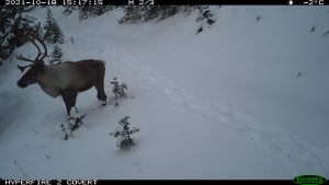
Reconyx photo of caribou bull on road 1A (treated in 2022)

Anne-Marie Roberts, Tweedsmuir Caribou Herd Program lead with the BC Ministry of Water, Lands and Resource Stewardship (WLRS) and Joanna Lee, BC Conservation Foundation (BCCF) contractor with WLRS share some lessons learned on the project so far.

Review of work to date: During the first year, the project was scoped out based on previous work and from projects in other areas of British Columbia and Western Canada. This allowed for beneficial streamlining of some of the work around restoration treatments and implementation development. Learnings from the initial year of the project also helped scope subsequent workplans, training, and reporting.

On Site Discussion: While this project utilized an experienced Project/Site manager on the machine work, a team site visit was held early before the machine work began to review implementation. Representatives from the BC Ministry of Water, Land and Resource Stewardship (Nadina Forest District + Skeena Region), Forest Carbon Initiative, Cheslatta Carrier Nation, and HCTF were in attendance and visited roads completed in previous years as well as roads to be completed in 2022 and had in-depth on-site discussions about restoration treatments and goals. This was an effective use of time to ensure that prescriptions were communicated and understood well by all involved. It also resulted in a better understanding from the machine operators that were newer to this type of project to know what the project was intending to achieve (i.e., plant-able spots, functional treatments aimed to reduce sightlines and minimize access and ease of movement).

Remote Cameras: On a more logistical note, cameras deployed in remote areas were a significant investment in time and money to deploy, check and process. Ensuring that cameras are protected as much as possible (bear boxes and possibly locks) is important to protecting the investment in that data.

Partners and Stakeholders: Working with First Nations and stakeholders is unique to each region and caribou herd, and it is essential to include inputs from different groups to this type of project. Adequate time must be set aside for meaningful input and to develop real partnerships for ongoing restoration. This will be important in the long-term implementation of restoration treatments. Through deep commitment to working together there has been significant contribution from First Nation partners to this project, caribou recovery, and in building capacity to support and lead components of this work.