Wed, 10 Jan 2024

Announcing the 2023 HCTF Photo Contest Winners

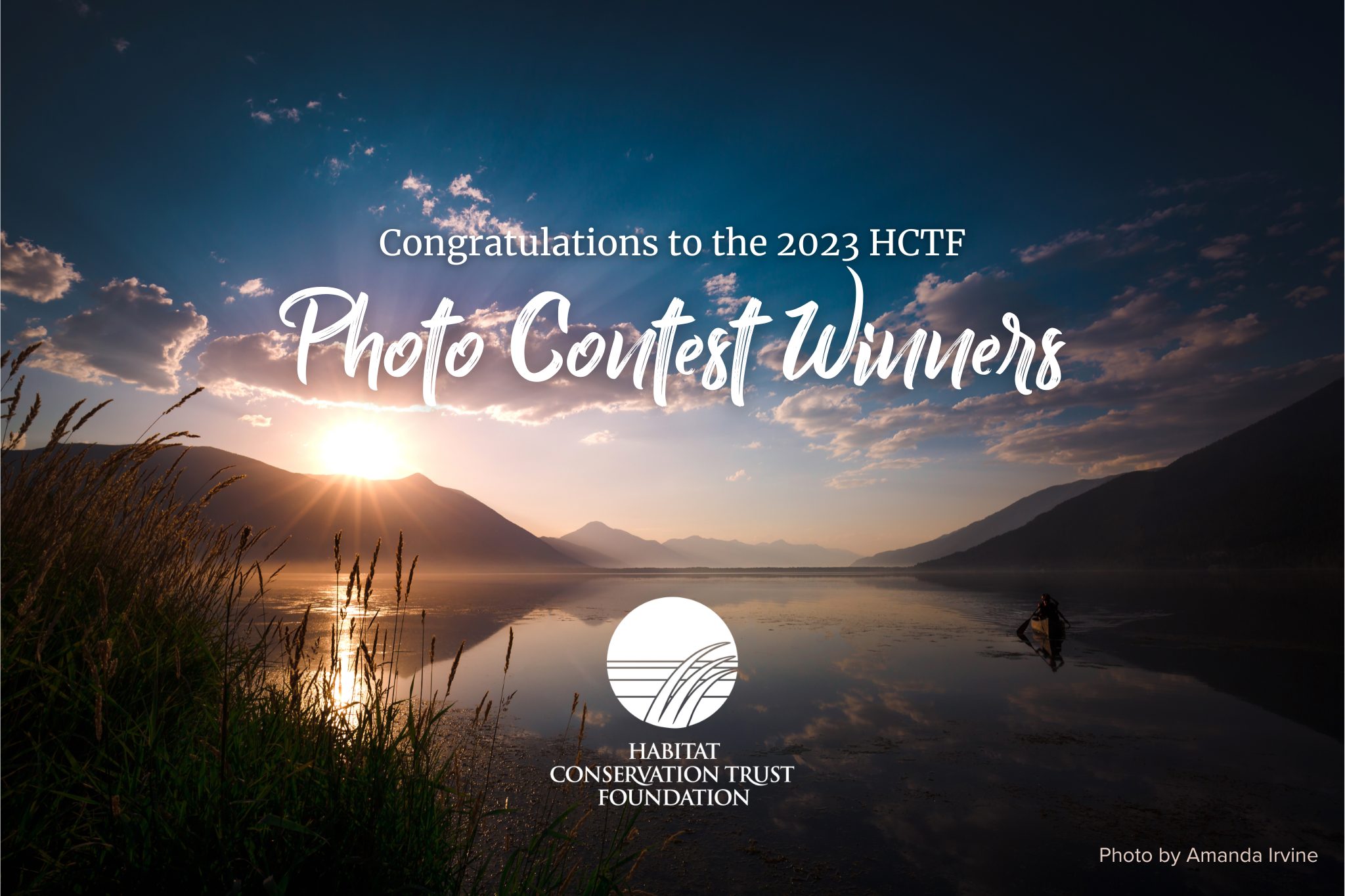
The results are in for the 2023 HCTF Photo Contest!

This year the contest returned to 3 categories: Wildlife or Freshwater Fish, Landscapes, and Conservation Lands. We received photos from all across our beautiful province, showcasing a broad range of species and habitats. Thank you to everyone who submitted a photo, and congratulations to our winners!

Category: Karen Wipond Award (Conservation Lands)

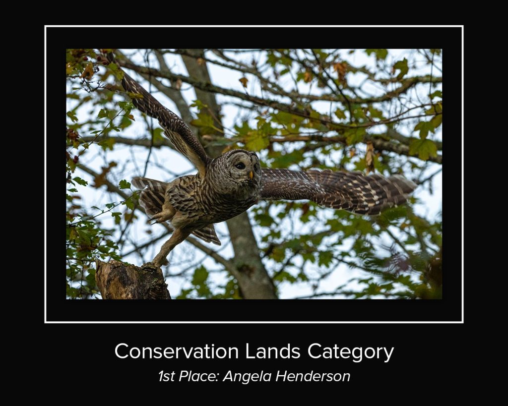
Angela captured this barred owl taking off in Buttertubs Marsh, a reclaimed urban wetland conservation land near Nanaimo BC. Barred owls often pose a threat to other owl species, and are considered invasive.

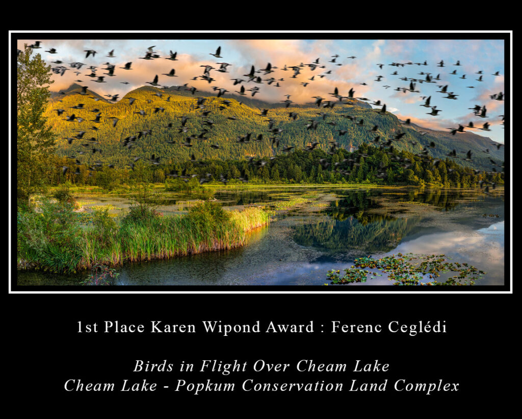
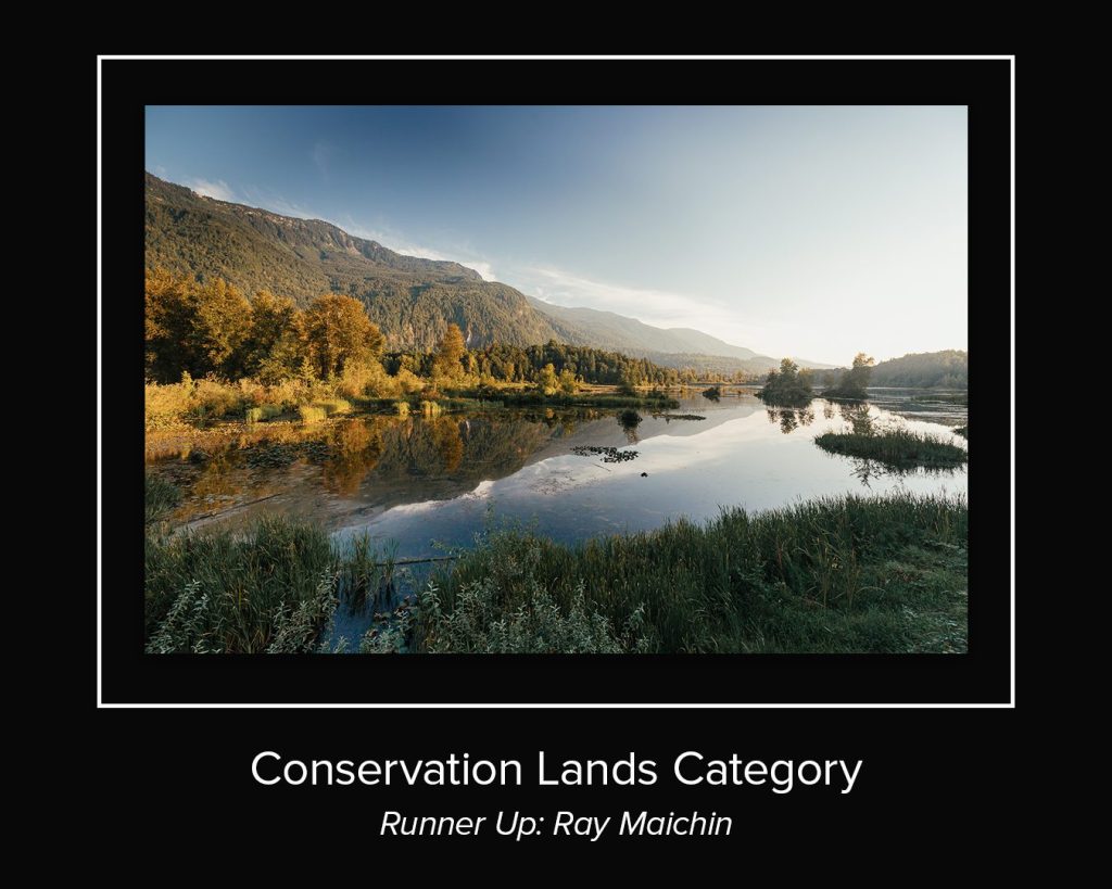
Ray took this beautiful image at Cheam Lake – Popkum, a 56 hectare biodiversity hotspot east of Chilliwack.


  • More info on Conservation Lands

    Photographs for the Conservation Lands (Karen Wipond Award) category must have been taken within the boundaries of a provincially administered Conservation Lands area in the province of British Columbia (see map below). While we encourage photographers and all nature-minded individuals to explore BC’s Conservation Lands we recommend that you research the Conservation Land you intend to visit beforehand, obey all safety requirements, public access best practices, and ethical guidelines when taking pictures of wildlife (for recommended ethical wildlife photography see the Audubon Society’s Guide). Conservation Lands are protected and managed for the purposes of conserving important habitat and ecosystem functions, and it is important that visitors do their part to maintain these sites for generations to come.

    Conservation Lands Map


Category: Wildlife or Freshwater Fish

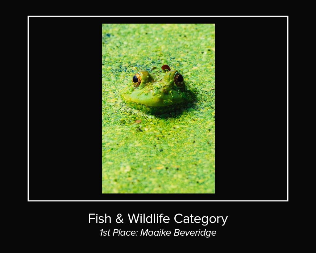
This captivating photo also highlights invasive species awareness. While a seemingly cute creature, this green frog is not native to the location where it was spotted near Victoria. For more info on invasive species of BC, visit bcinvasives.ca. Report sightings of invasive species via the Report Invasive Species app or online at gov.bc.ca/industry/report-an-invasive-species.

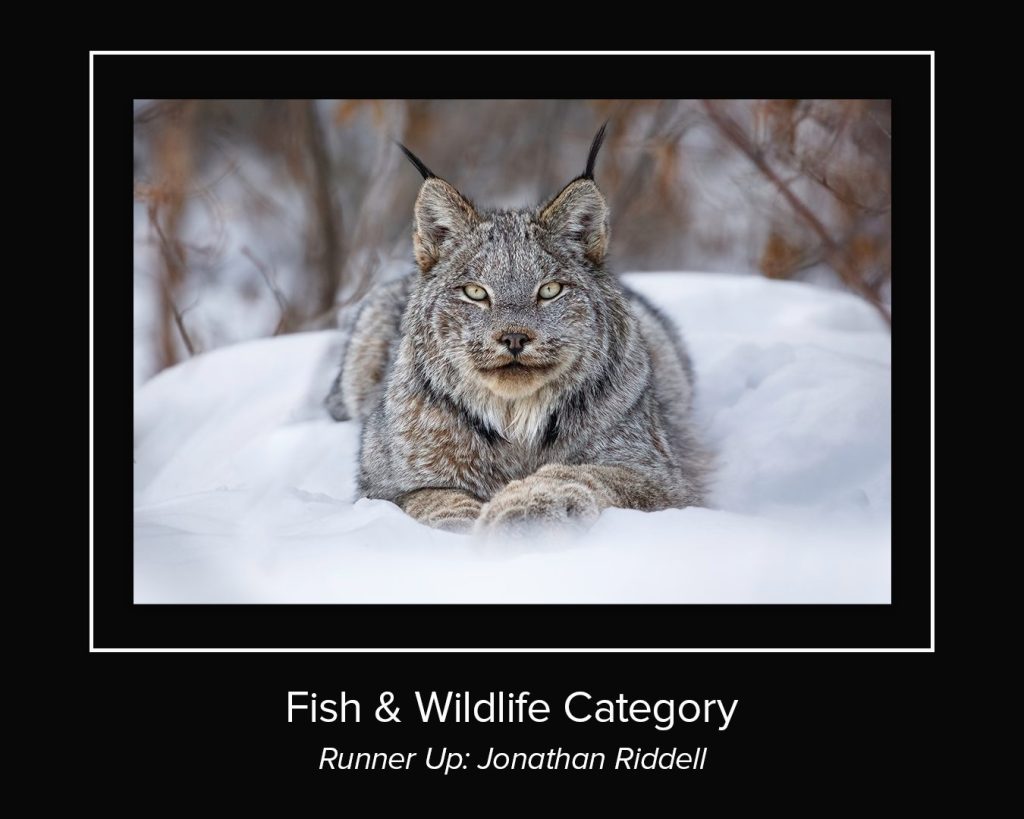
Jon snapped this beautiful lynx photo in the Taiga Plains eco-region of northeast BC, near Fort Nelson.

Category: Landscape

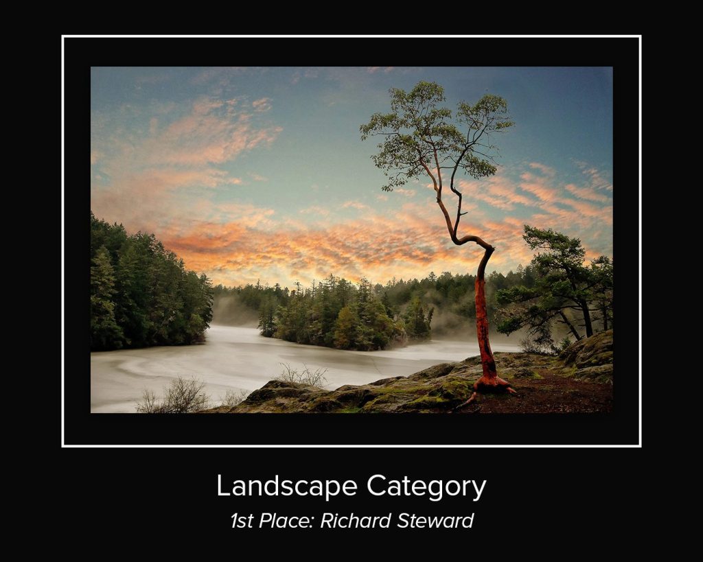
Richard’s incredible photo was taken in upper Thetis Lake, near View Royal BC. A brief cold snap formed a thin layer of flat ice on the lake which provided a beautiful background for a lone arbutus.

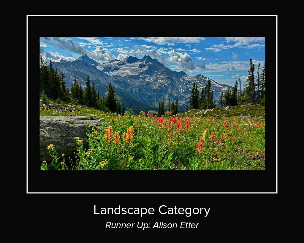
Alison’s beautiful photo, taken in the Silent Pass area near Golden, has the Spillimacheen Glacier in the background and red paintbrush and Arnica blooms in the foreground.

Fri, 2 Dec 2022

Winners of the 2022 Conservation Lands Photo Contest

The results are in for the winners of the 2022 HCTF Conservation Lands Photo Contest!

The 2022 Habitat Conservation Trust Foundation’s Photo Contest encouraged photographers and BC residents to get out to Conservation Lands across the Province to enjoy the natural beauty British Columbia has to offer.

1st Prize: Karen Wipond Award

2nd Prize

3rd Prize

Honourable Mention

Conservation Lands

The winning photographs were taken within the boundaries of provincially administered Conservation Lands in the province of British Columbia (see map below). While HCTF encourages photographers and all nature-minded individuals to explore BC’s Conservation Lands we recommend that you research the Conservation Land you intend to visit beforehand, obey all safety requirements, public access best practices, and ethical guidelines when taking pictures of wildlife (for recommended ethical wildlife photography see the Audubon Society’s Guide). Conservation Lands are protected and managed for the purposes of conserving important habitat and ecosystem functions, and it is important that visitors do their part to maintain these sites for generations to come.

The primary purpose of conservation lands is to conserve and manage important habitat for the benefit of regionally or internationally significant fish and wildlife species. This includes habitat that is vital for:

  • Sensitive, vulnerable, or at-risk species.
  • Critical species life-cycle phases such as spawning, rearing, nesting, or winter feeding.
  • Species migration routes or other movement corridors.
  • Supporting unusually high species productivity or diversity.

Conservation lands often concurrently provide for a range of opportunities for public access, including day hiking, hunting and fishing, wildlife viewing, scientific research and education, and traditional activities of First Nations.

Map of BC Conservation Lands

Fall Site Visits: Stewardship, Sheep and Salmonids

Staff visit to Salmon River Estuary Conservation Area; Jade Neilson, Karen Wipond, Tom Reid, Christina Waddle, Shawn Lukas (from left to right)

HCTF staff enjoyed some time out in the field this fall with visits to project sites around the province. Each year, HCTF undertakes project evaluations on a sample of projects to conduct a financial review, and to ensure conservation objectives are being met.

The first evaluation took place in September with the Nature Kids program, a Stewardship project which aims to engage children and their families with nature through hands-on learning, stewardship activities and citizen science projects. HCTF staff visited the program’s office in North Vancouver and one of the weekend events in Greater Victoria called “Hawkwatch”.

The Raptors live demonstration at Hawkwatch.

In October, staff travelled to the Kootenays and visited 2 project sites with Irene Teske, Wildlife Biologist with the Ministry of Forest, Lands, Natural Resource Operations and Rural Development (FLNR). Staff got a first-hand look at areas being treated to control invasive plants such as Yellow Hawkweed and St. John’s Wort at Bull River and Wigwam Flats, both conservation areas in the East Kootenay region. For this project, HCTF Special Permits (Wild Sheep) funding is being used to restore native grasslands to improve winter forage for Bighorn Sheep.

2008 photo of the Bull River bighorn herd. Beginning in 2009, wildlife managers noticed a rapid spread of yellow hawkweed and other invasive plant species in this herd’s winter range.

The next visit was to a very different landscape on the east coast of Vancouver Island. HCTF visited three sites funded under the Conservation Lands Operations and Management (O&M) Funding Program: S’amanu Wildlife Management Area (WMA), Nanaimo River Estuary Conservation Area, and the Salmon River Estuary Conservation Area. This program provides $550,000 annually to FLNR for O&M costs on ministry-administered conservation lands across the province including lands leased from the Nature Trust of BC. Funding for this program is provided primarily through endowment funds provided to HCTF from the Province of BC.

HCTF staff and the FLNR Conservation Lands Specialist Karen Wipond received a tour hosted by the West Coast Conservation Land Management Program (WCCLMP) staff Tom Reid and Shawn Lukas, demonstrating how HCTF O&M funding is being used to maintain conservation values at the selected properties.

At the S’amanu WMA, we viewed and discussed the restoration work and new interpretive signage at Ye’yumnuts, a sacred ancestral place of the Cowichan people. We also discussed invasive species management supporting species at risk on the site, and agricultural activities to enhance forage for wintering waterfowl.

After leaving S’amanu, we travelled north to the Nanaimo Estuary, the largest estuary on Vancouver Island, with riparian, marsh, and intertidal ecosystems including eelgrass beds, supporting thousands of over-wintering birds and juvenile salmonids. We viewed some restoration work in action while program staff and partners tested nets in the estuary to monitor juvenile salmonids in the coming spring. HCTF funding is also being used to develop improved elevation and vegetation mapping in the estuary which will help support management decisions and plan future restoration and enhancement projects.

Nanaimo Estuary including split rail fencing used to control access and direct visitors.

The third site we visited with WCCLMP staff was the Salmon River Estuary Conservation Area near the Village of Sayward. An HCTF Enhancement and Restoration Grant was used for habitat enhancement work for Roosevelt Elk and other species on the property purchased in 2015, the acquisition of which was also supported by HCTF. This restoration project included thinning the alder forest and planting to improve forage for Roosevelt elk, removing Scotch Broom and replanting with native species, and creating shallow wetland habitat with wood structures to improve habitat for amphibians.

Enhanced wetland habitat at the Salmon River Estuary Conservation Area.

HCTF staff appreciated the opportunity to see the great work funded across the province. The HCTF evaluation process provides an additional check and balance in addition to our rigorous proposal review process to ensure conservation objectives are realized and we see a positive difference for fish and wildlife and their habitats, as intended by our various contributors.

Tue, 30 Oct 2018

Collaboration and Knowledge Sharing at Conservation Lands Operations and Management Funding Program Meeting

Lands Management Group Photo

On September 18-19th 2018, Habitat Conservation Trust Foundation (HCTF) hosted a meeting of conservation land managers in Penticton, BC. These managers receive funding under the HCTF Conservation Lands Operations and Maintenance Funding Program administered in partnership with the Ministry of Forests, Lands, Natural Resource Operations and Rural Development and the Nature Trust of BC. HCTF currently provides $617,500 annually to assist with the operation and maintenance of approximately 115 significant wildlife habitat areas across BC.

This gathering represented the second opportunity for land managers and other stakeholders to come together in person since the establishment of our new partnered approach to administering operations and management funding. Taking a partnered approach to conservation lands management has a number of benefits, including the ability to combine assets and expertise, avoid duplicating efforts and leverage funding.

The meeting was a great opportunity for practitioners from across BC to share knowledge, give feedback on the administration of the program, discuss plans for its evolution, and collaborate to help improve conservation land management in the province.

A highlight of the two-day event was the field trip, which provided opportunities to witness conservation land management in action.

HCTF staff Christina Waddle hiking

First stop on field day was the McTaggart-Cowan/nsək’łniw’t Wildlife Management Area. This site is close to the heart of HCTF, as it is named in part for HCTF’s Founding Chair. The site name also honours the Penticton Indian Band; “nsək’łniw’t” is roughly translated from the Syilx language as “a gash on the side” and refers to a historic trail used for travel, trade, and access to medicine-gathering areas. The group then traveled onward to Skaha Lake Eastside, Vaseux Lake, and finally the South Okanagan Wildlife Management Area. Along the way, they shared common experiences, best practices and challenges related to conservation land management including wildlife usage, mineral claims, grazing, and infrastructure maintenance.

Overall, HCTF was pleased to help facilitate this important gathering and opportunity for conservation land managers to share knowledge and experience. We are in the process of refining the program administration details for the upcoming funding cycle, and look forward to incorporating the vital on-the-ground experience and feedback that was received during the event.

All photos generously provided by Karen Wipond.

Wed, 31 Aug 2016

Monitoring Vancouver Island Estuaries

Installing-SET-Platform_Cluxewe_July2016

Thanks to Karen Barry from the VICLMP program for sending us this project update!

The Vancouver Island Conservation Land Management Program* has initiated a long term monitoring program to assess the health of estuaries and salt marshes on the east coast of Vancouver Island with support from HCTF and other partners. The goal of this monitoring program is to ensure that conservation lands provide high quality, accessible habitat for fish and wildlife, and to identify conservation concerns resulting from threats such as sea level rise, invasive species, or other human-induced changes. By implementing a standardized monitoring program, we can ensure investments made towards protection of sensitive estuaries are secured for the long-term.

To determine the resiliency of coastal estuaries to sea level rise, we are installing Surface Elevation Tables (SET) platforms in several estuaries this summer, including Quatse River, Cluxewe River, Salmon River, Englishman River, Nanaimo River and Cowichan River estuaries. These devices allow us to see how salt marshes and estuaries are changing over time, by measuring changes in elevation of the substrate. The SET consists of an aluminum platform that is permanently installed in the estuary and anchored to prevent any movement. To take measurements, a specialized reader arm is brought out to the estuary, mounted to the platform and several rods are lowered from the arm onto the surface. Because the location and orientation of the device is fixed during sampling, we can record highly precise elevation measurements. Annual fine-scale readings are compared over time to see how much deposition or erosion is occurring.

When measurements indicate a positive change in elevation, it means that sediment is being deposited, the plants are healthy and stabilizing the sediments, and the underlying marsh soils are getting thicker (accreting). This is a natural process in healthy salt marshes which increases the resiliency of estuaries to rising sea levels. In contrast, negative readings indicate decreasing elevation which means that the marsh surface is sinking (subsiding) or eroding. When the rate of sediment deposition (or accretion) does not match or exceed the rate of subsidence or sea level rise, the salt marsh can eventually “drown” meaning that it becomes sub-tidal. This can result in significant habitat changes for fish and wildlife; for example, vegetated salt marshes can become unvegetated mud flats.

Results from our SET measurements will provide important information about local ecosystem change that can help inform management. Specifically, we will gain a better understanding of whether our estuaries are resilient over the long term, what habitats may be most vulnerable to sea level rise, and what potential restoration actions may be warranted to maintain or improve fish and wildlife habitat.

* The Vancouver Island Conservation Land Management Program (VICLMP) is a strategic partnership program with Environment Canada-Canadian Wildlife Service, the Ministry of Forests, Lands and Natural Resource Operations, Ducks Unlimited Canada, The Nature Trust of British Columbia, and funding from Habitat Conservation Trust Foundation. VICLMP’s work focuses on managing over 100 conservation areas on Vancouver Island and the central and north coasts.