Wed, 20 Jan 2021

Invasive Mussels Monitors Adapt to The New Normal

Robyn Hooper of CSISS - Invasive Mussel Sampling

Despite the challenges posed by the global pandemic, conservation organizations from across BC were out in full force this summer to ensure that BC’s lakes remain free of invasive mussel species.

2020 marked the third season that Habitat Conservation Trust Foundation (HCTF) has partnered with the Ministry of Environment and Climate Change Strategy (ENV) to support invasive mussel monitoring in BC’s lakes.

Although 2020 posed new and unique challenges for conservation practitioners, it has not stopped our conservation partners from carrying out important monitoring work for invasive zebra and quagga mussels (ZQM) across the province. This year, it was essential to adapt practices in the field to ensure that all the appropriate COVID-19 precautions were taken to keep both the conservation groups and the communities they were visiting safe. Despite the additional challenges, we are proud to report that nearly $150,000 in funding from the BC Ministry of Environment and Climate Change Strategy (ENV) and the Federal Department of Fisheries and Oceans (DFO), was provided to 12 groups across the province this year to support lake monitoring efforts as part of the provincial Invasive Mussel Defence Program.

The goal is to prevent the introduction of invasive zebra and quagga mussels (ZQM) into B.C. The program’s prevention efforts are focused on inspecting boats, monitoring lakes, educating the public and coordinating action with neighbouring jurisdictions. Invasive ZQM have been steadily moving westward across North America since the late 1980s, it is critical to identify them as early as possible so they can be controlled before they have a chance to spread throughout our waterways. Native to Eastern Europe, these invasive mussels can have a severe effect on native freshwater ecosystems, disrupting food chains, impacting fish populations, and even pose a danger to swimmers who may cut themselves of the mussel’s razor-sharp shells.

Given the threat that these invasive species pose to BC’s aquatic ecosystems, fishing recreational industries, aquatic infrastructure and other economic factors it is key that conservation groups monitor our waterways on a yearly basis. 2020 threw our conservation partners the added challenge of conducting sampling while maintaining safe COVID-19 precautions. Conservation groups such as the Lillooet Regional Invasive Species Society, and East Kootenay Invasive Species Council, rose to the occasion.

“Due to the global pandemic, the East Kootenay Invasive Species Council (EKISC) moved from small motorboat sampling while partnering with government staff to shoreline and/or dock sampling utilizing the in-house crew only. This increased our capacity to visit 15 waterbodies throughout June to September.” said Danny Smart, Field Operations Coordinator for the EKISC.

Other organizations such as the Lillooet Regional Invasive Species Society (LRISS) partnered with local communities and First Nations to ensure that, despite the challenges posed by COVID-19, their vital monitoring activities could continue. Jacquie Rasmussen, Executive Director for LRISS reports that “LRISS works very closely with the P’egp’ig’lha-T’it’q’et community and was able to get a permit to access the lake to do our sampling this summer even when the lake was essentially “closed”. This allowed T’i’t’q’et staff monitoring gates to let us through to take our samples. We are extremely grateful for our partnerships with the St’át’imc, HCTF and ENV to make this sampling possible.”

Conservation work and invasive species monitoring is vital to maintaining the biodiversity, health and resilience of BC’s unique and varied ecosystems. It is heartening to know that despite the presence of unforeseen and significant challenges, conservation organizations are adaptable and dedicated to safeguarding BC’s natural places.

How you can help:

  • Report any suspected invasive species via the Provincial “Report Invasives BC” smartphone application (available for download from gov.bc.ca/invasive-species) and any suspected invasive zebra or quagga mussels to the Report All Poachers and Polluters hotline 1-877-952-7277.
  • Clean Drain Dry when moving gear and watercrafts from one waterbody to another. Remove all plants and mud before moving to a new water body. Properly drain all compartments, pull the drain plug and allow to dry before moving to another waterbody.

HCTF’s Invasive Mussel Monitoring Grant program will continue in 2021, if you are interested in participating HCTF is accepting grant applications for the Invasive Mussel Monitoring Grant Program now until February 3rd, 2021.

Tue, 17 Nov 2020

Wildlife habitat for Bighorns Protected

Lot A DL 493 photo provided by SILT

A further 35 hectares (86 acres) of grassland habitat two kilometres east of Grand Forks on Morrissey Creek Road has been purchased for wildlife conservation by the Southern Interior Land Trust (SILT).

Purchase of these open, south-facing bunchgrass slopes with patches of deciduous shrub thickets provide habitat for a number of species, including year-round use by the Gilpin Herd of California bighorn sheep, 200-300 animals, including all ages, for its forage and security habitat.

Funds for the purchase included donations from the Habitat Conservation Trust Foundation, B.C. Conservation Foundation, Tom and Jenifer Foss, the Wild Sheep Society of B.C., Wild Sheep Foundation Alberta, other individual donors, and the Government of Canada through its Natural Heritage Conservation Program.

An adjacent 109 hectares (270 acres) was purchased earlier this year by SILT, with support from the Walter Mehmal Family, and contributions from the B.C. Conservation Foundation, the Brandow Family, the Wild Sheep Society of B.C., the Grand Forks Wildlife Association, and other donors.

SILT is a volunteer-run, not-for-profit charity dedicated to conserving land for all living things.

President Judie Steeves comments, “We’re delighted we’ve been successful in our collaboration with so many different interest groups and individuals to conserve these two properties. Now we need to work with the local community to prevent motorized use of these grasslands, so they are not destroyed for use by wildlife. Otherwise, the public is welcome to hike over and enjoy the scenic wild beauty of this land.

“As well as wild sheep, there are both mule and white-tailed deer; rattlesnake, gophersnake and racer; and birds such as canyon wren which I recently spotted there. An endangered badger was sighted on the property this past August. Both properties have habitat for at least six federally-listed species-at-risk.”

“We are proud to once again be a partner in this project that leaves a conservation legacy that will forever be upon the landscape. Resources like this will ensure that future generations have the opportunity to see untouched wild spaces in perpetuity” – Kyle Stelter, past-president of the Wild Sheep

“Society of B.C.A shout out to the conservation-minded people, the hunters, the non-hunters and the organizations that made all of this possible. SILT and this acquisition are examples of how we can pull together even in these very tough times” – Tom Foss of the Foss Foundation

“The BCCF is pleased to be able to support the SILT acquisition of land for protection of important bighorn sheep and mule deer habitat, as well as other species” – Gerry Paillie of the BCCF Land and Wildlife Committee

SILT owns two other properties in the Grand Forks area, Edwards Pond and at Wards Lake, as well as properties at Keremeos, Cawston, and the R.E. Taylor Conservation Property on Keremeos Creek near Olalla.

SILT welcomes inquiries from people interested in gifting land, or from anyone wishing to donate to help conserve lands containing important natural features. For details, go to the SILT website at: siltrust.ca

Wed, 16 Sep 2020

At-risk population of grizzly bears to benefit from successful conservation initiative in Pemberton Valley

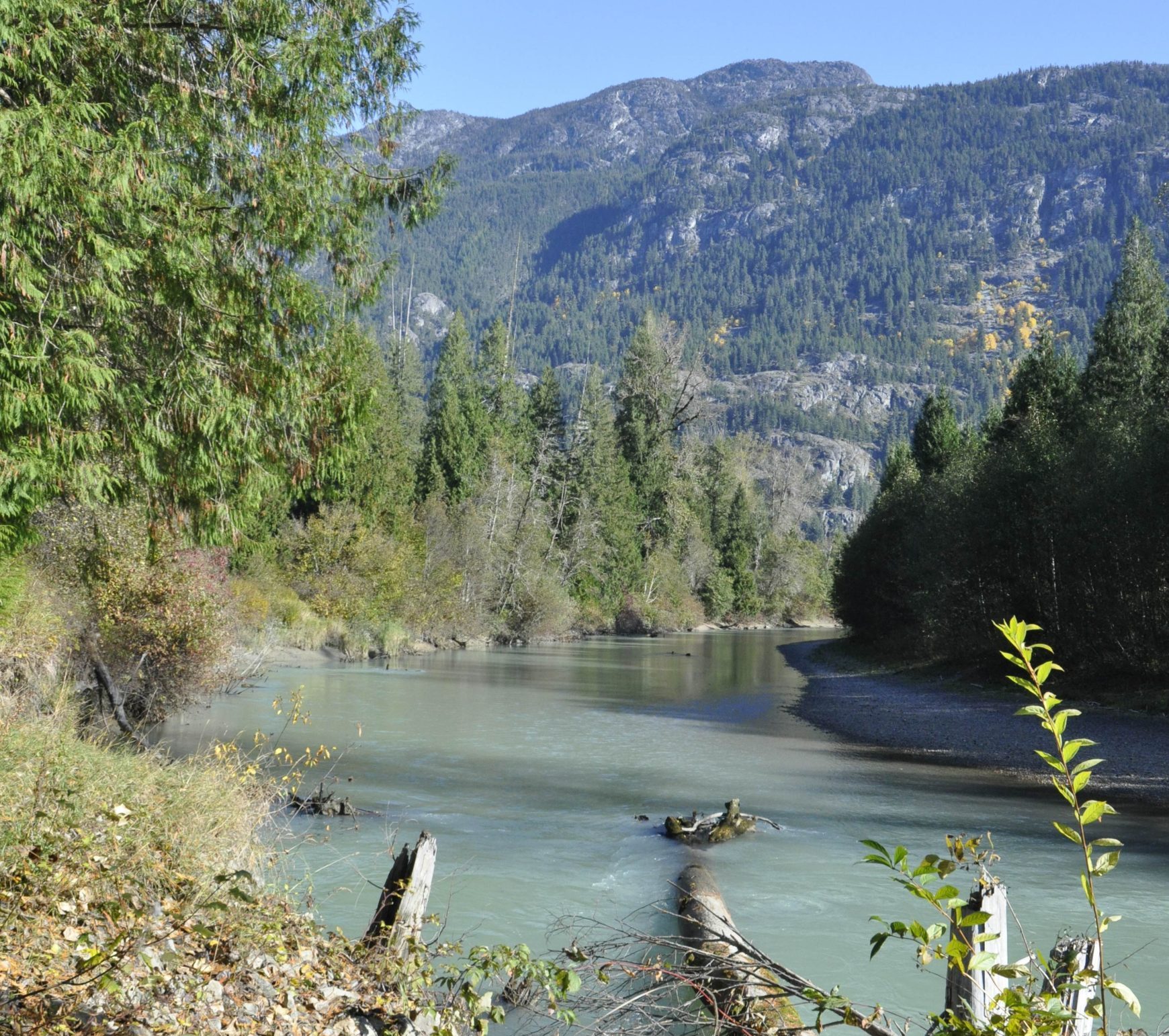
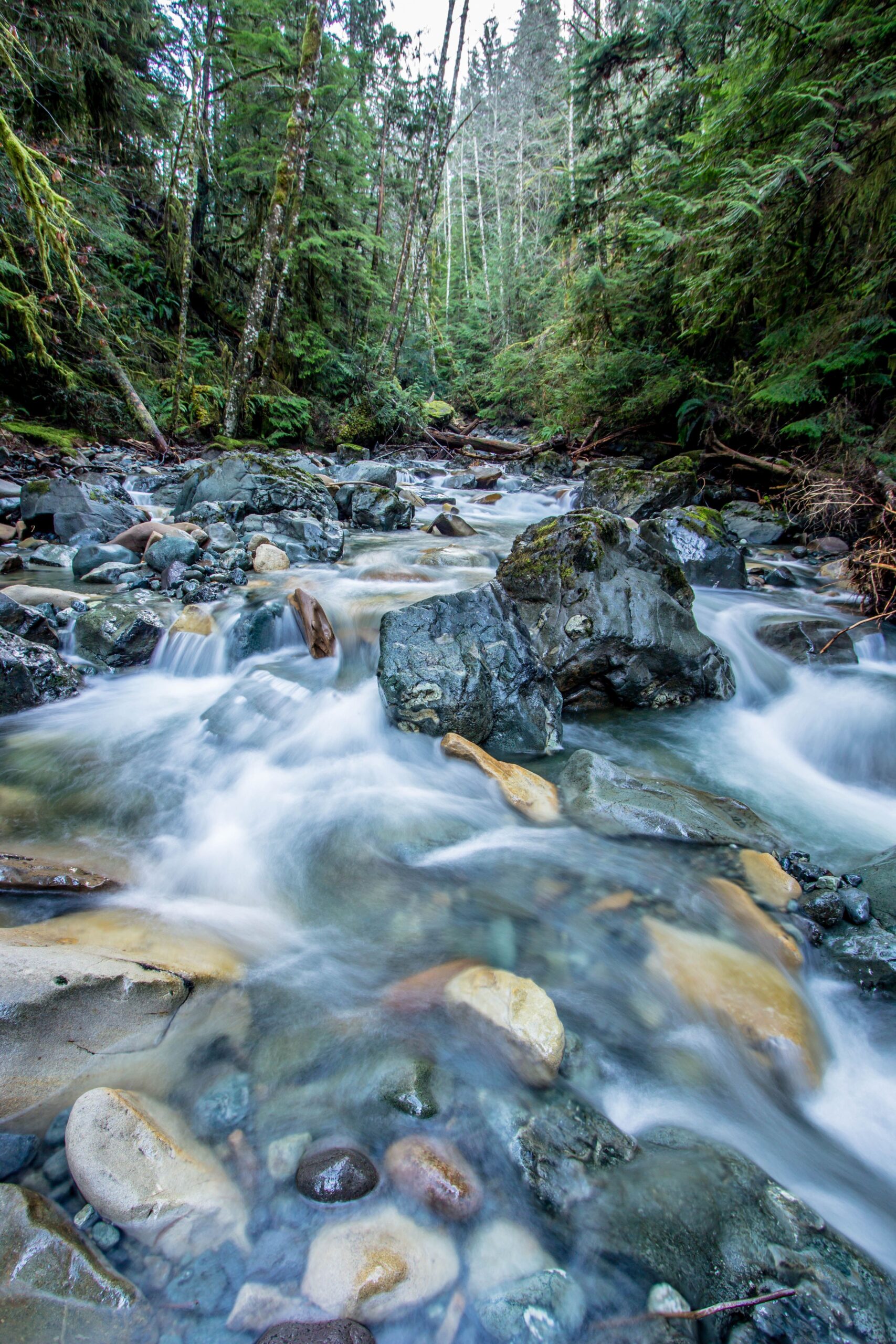
Ryan River Misty Morning by Fernando Lessa

Crossing through the Pemberton Valley just got a little more secure for the dwindling population of grizzly bears that live in the Squamish-Lillooet region. The Nature Conservancy of Canada and its partners have conserved an 87-hectare (214-acre) ecologically important property along the Ryan River, in Pemberton Meadows.

The Ryan River Conservation Area is extensively used by wildlife, including grizzly bear, deer, beaver and migratory birds. The grizzly bears in this area are considered at risk, designated as being of special conservation concern both provincially and federally. Protecting these undeveloped lands that the bears use to move across the valley is essential for maintaining connectivity between populations.

The new conservation area protects two kilometres of riverfront habitat, as well as seasonally flooded wetlands, a large marsh and forested uplands that contain stands of old-growth cedar, cottonwoods, and hemlock trees. The Canadian Wildlife Service identifies these wetlands as being of the highest ecological quality. The river provides important spawning and rearing habitat for salmon and other fish species. As one of the largest remaining intact private valley-bottom parcels, the conservation of this property safeguards essential and flourishing wildlife habitat from development pressures.

The property had been in Bruce Miller’s family for three generations. Miller grew up exploring the forests and wetlands with his father, developing a love of the land that he, in turn, passed on to his own children, who also grew up playing on and learning from this land. The Miller family was keen to see this property kept natural and intact, and so they chose to work with the Nature Conservancy of Canada to conserve it.

This project has been made possible by the contributions of many funders, including the Government of Canada, through the Natural Heritage Conservation Program, part of Canada’s Nature Fund, the Pemberton Wildlife Association, Habitat Conservation Trust Foundation, the Longhedge Foundation, the U.S Fish and Wildlife Service and several individual donors.

The Pemberton Wildlife Association, Coast to Cascades Grizzly Bear Initiative, and Conservation Northwest provided valuable local insight into the natural values in the Pemberton Valley and contributed input into the Nature Conservancy of Canada’s priorities for conservation action in the area.

The Ryan River Conservation Area is the Nature Conservancy of Canada’s first project in the Pemberton Valley.


“The Pemberton Valley, like so many valleys in BC, is a popular place to live, work and play. This can put a lot of pressure on the natural systems and wildlife in the area. Making conservation one of our priorities in these ecologically rich areas benefits both people and nature. We are grateful to all our partners and donors who came together to enable the creation of the Ryan River Conservation Area. It is a spectacular contribution to conservation in this important area and to our shared future.” – Nancy Newhouse, BC Regional Vice President, Nature Conservancy of Canada

“Our family is very excited to have the opportunity to be part of conserving and protecting this very special property.” – Bruce Miller, landowner

“The Pemberton Wildlife Association is very supportive of the Ryan River project, which preserves outstanding natural wetland and riparian wildlife habitats. Migrant songbirds are a common sight and are known to nest in the area. Streams on the land here are used by cutthroat trout and coho salmon. Grizzly bears have been spotted here in the spring, likely seeking forage after emerging from their dens. For these reasons and many more, this is an important local conservation project, and our club is excited to be a part of it.” – Allen McEwan, president, Pemberton Wildlife Association

“On behalf of the Honourable Jonathan Wilkinson, Minister of Environment and Climate Change, I congratulate the Nature Conservancy of Canada for its creation of the Ryan River Conservation Area in British Columbia. The preservation of this riverfront habitat, with the support of the Government of Canada’s Natural Heritage Conservation Program, will protect biodiversity and ensure that species at risk can thrive for generations to come. With help from partners like Nature Conservancy of Canada, we are making progress toward our commitment of conserving a quarter of Canada’s land and a quarter of its oceans by 2025.” – Patrick Weiler, Member of Parliament for West Vancouver—Sunshine Coast—Sea to Sky Country

“HCTF is proud to support the conservation work of the Miller family, NCC and the partners who are protecting this biologically diverse property for BC’s fish and wildlife. The forest, wetlands and adjacent Ryan River create a unique juxtaposition of habitats that improve conservation outcomes for our bears, birds, trout and multitude of other species. Congratulations to the partners for achieving this project!” – Dan Buffet, CEO, Habitat Conservation Trust Foundation

Tue, 1 Sep 2020

Perseverance Pays Off

Perseverance Creek, photo by Sara Kepner

Perseverance has paid off and on September 1st the Cumberland Community Forest Society (CCFS) completed the purchase and protection of 226 acres of beautiful forest and creek in the Perseverance Creek Watershed.

The Perseverance Creek purchase is the largest and most costly to date for the CCFS. This ambitious 2.5-million-dollar project has also been unique from the previous 3 purchases the CCFS have made due to historic impacts on the landscape and the complex creek system that runs through it. Perseverance Creek is a salmon-bearing tributary into Comox Lake and the drinking water supply for over 45,000 Comox Valley residents. The protection of the Valley’s drinking water is the responsibility of the Comox Valley Regional District (CVRD) and the purchase was supported as part of Comox Lake Watershed Protection Plan (WPP).

This has been a truly remarkable journey and an inspiring collective effort. This 2.5 million dollar undertaking would not have been possible without the profound collaboration of individuals, families, artists, athletes, restaurants, brewpubs, professionals, businesses, local government, foundations, and community organizations big and small. CCFS would like to thank everyone involved for being part of this historic conservation effort.

The CCFS is celebrating its 20th anniversary this year. Formed in the year 2000 by a group of village residents concerned about logging adjacent to the community, the CCFS has since purchased and protected over 500 acres of threatened forest lands. These lands are protected for ecological conservation and low-impact recreation. As part of this recent purchase process, the CCFS has also become a conservation covenant holding organization, and the CCFS joins their partners and friends at the Comox Valley Land Trust in holding responsibility for the long-term protection of the forest. CCFS expresses how much of an honour it has been to hold this responsibility on behalf of our community.

The work has only just begun and restoration, regeneration, and biodiversity projects are already under development to begin to address historical impacts on the landscape. The business of buying and protecting land doesn’t stop once the purchase is made. Together we all have a responsibility to be stewards and active partners in caring for these lands and waterways and the living things that call it home.

Tue, 11 Aug 2020

Habitat restoration across the Klinse-Za caribou herd range

HCTF’s Caribou Habitat Restoration Fund (CHRF) provides funding for restoration of critical habitat for BC’s caribou herds. This includes multiple projects designed to benefit the Klinse-za herd led by the Nîkanêse Wah tzee Stewardship Society, a joint initiative of the West Moberly and Saulteau First Nations. The Society is working in partnership with a team from Wildlife Infometrics to restore disturbed habitat. Wildlife Infometrics recently shared the following update focused on the monitoring component of this work.

Why restore?

The Klinse-Za herd area, located between Mackenzie, Chetwynd and the Peace Arm of Williston reservoir, used to support a herd of almost 200 caribou as recently as 1995 and was said to be so numerous in historic times as be “like bugs on the land”. However, the herd has declined to under 40 individuals by 2013. Across BC, many caribou herds have experienced the same steep declines, and most of the struggling herds are inhabiting areas with generally more human disturbance and activity on the landscape. Specifically, industrial development has contributed to caribou declines as their habitat has been altered, displacing the caribou and making them more susceptible to predation. Since 2013, costly and intensive management efforts including maternity penning and predator removal have helped halt or reduce the rate of decline in some herds. However, these activities are not going to keep caribou on the land base over the long term. To improve caribou habitat, support the ecosystem and balance the predator-prey dynamics, we are implementing a large-scale habitat restoration project in the Klinse-za caribou herd area.

A road from low to high elevation provides an easy travel corridor for predators to access alpine refugia for caribou.

Restoration of habitat can involve a variety of activities. In the Klinse-za habitat restoration program, we focus our efforts on reforesting and restructuring linear features (e.g., old roads, seismic lines). This will limit the ability of predators to easily access caribou habitat and minimize caribou- predator interactions. Over time, reforesting the features will return the ecosystem to a more natural state.

Why monitor?

Crew member installing trail camera over an old road.

Our restoration project has two components, both equally important to the long-term success and usefulness of this endeavor. The ‘implementation’ piece is where features on the landscape actually change the way they look, appear to wildlife, or function within the ecosystem. These are the actions that include road structure modifications, tree planting, access alterations and other physical changes. To evaluate how much of a difference these changes made and how caribou and other wildlife are responding to them, we have a detailed monitoring program of data collection and analysis. It’s the monitoring that allows us to understand whether we’re meeting our objectives and make improvements to our plans if necessary.

Currently, our monitoring program has two main components: measuring changes in vegetation in response to restoration of linear features, and tracking wildlife and human road users through a network of trail cameras.

Trail camera discoveries

Motion activated trail cameras allow us to ‘have eyes’ across very large spatial extents, at all hours of the day and night. Since we currently have 200 cameras deployed across 7 different sites, we are monitoring a total of about 50 km of linear features. This large scale has allowed us to capture some interesting, valuable and sometimes surprising footage of the four-legged residents of our project area. One of the most vivid observations to date has been the large number of grizzly bears across the area – we have observed many sows with 2 to 3 cubs in tow, large males and several bears having a good scratch on trees, though our favourite picture remains a beautiful sunset image of a sow walking down the road with her three cubs!

Above: a grizzly sow walking down the road with her three cubs. Below: a tense face-off between wolf and moose – we don’t know what the outcome was.

We have also observed a wide suite of other predators, including black bears, wolves, cougars, lynx, coyotes, wolverines, and more. While we are hoping to reduce predator access into alpine areas, it is nonetheless interesting to see such a diversity of predators in one area. We also see ungulates making extensive use of the linear feature, with moose being most abundant. Caribou and elk are both seen periodically.

Vegetation sampling: getting into the weeds

Tracking vegetation is important for two reasons. First, plants are essential as they form the basis of the food chain: vegetation provides energy to herbivores (large and small), who in turn support a variety of predators. Second, plants are highly responsive to environmental conditions such as moisture, shade, and soil type, and can thus be effectively used as indicators of habitat change. Since our goal with restoration is to alter existing linear disturbances so that they more closely resemble the surrounding habitat, we use a ‘before-and-after’ vegetation sampling approach. Specifically, we are collecting data about the plants on and near the linear features now (the ‘before’), and will collect the same data at intervals from one to ten years after we carry out the restoration activities, so that we can evaluate whether the restoration has been effective.

Crew members Warren Desjarlais and Mariah Mueller identifying
plant species.

While spending long field days identifying and counting plants can be a little hard on the back and somewhat repetitive, there are many delights in this work for the ‘plant nerds’ on the project. Identifying rare species or unusual color variants keeps us on our toes and sometimes requires impromptu group debates right on the mountain. Because the sampling sites are spaced hundreds of meters apart, we get to hike through a variety of elevations and ecotypes and see beautiful country. Finally, this kind of intensive field sampling provides valuable real- world training opportunities in plant identification, and so we include First Nations community members and/or summer students on our crews to help them develop their expertise and confidence.

Thanks again to Wildlife Infometrics on behalf of the Nîkanêse Wah tzee Stewardship Society for providing this update on their work!

Fri, 4 Oct 2019

Conservation Property Dedicated to Lifetime Conservationist Ron Taylor

The Southern Interior Land Trust (SILT) recently added a fifth property to its conservation holdings—a gem of intact streamside water birch habitat on the banks of Keremeos Creek near Olalla.

On Saturday, September 28th, SILT dedicated it the “R.E. Taylor Conservation Property” to honour Ron Taylor of Winfield, BC, in recognition of Ron’s life-long commitment to wildlife conservation. A career teacher and avid outdoorsman, Ron has influenced and mentored hundreds of young and old hunters, fishers, trappers, biologists and conservationists. Ron, through his strong conservation ethic, has always spoken on behalf of fish and wildlife and for the wise use of wild spaces.

Ron helped to create SILT, a non-profit land trust, and has served on its Board of Directors since the society was formed in 1988. He has been an active member of the Oceola Fish and Game Club for decades and has also served on its executive and that of the BC Wildlife Federation. Ron spent years advocating for a balance of natural resource use and protection at the Okanagan-Shuswap Land and Resource Management planning table. He has also served for several years on the Board of the Habitat Conservation Trust Foundation. Ron’s willingness to share his time and knowledge to so many fish and wildlife related endeavours has had positive and lasting impacts on natural resource management in BC.

Situated on flat valley bottomland, the R.E. Taylor Conservation Property provides habitat for at least six federally listed species at risk including yellow-breasted chat, western screech owl, Lewis’s woodpecker, barn owl, badger and common nighthawk. Deer, bear, moose, bobcat and other wildlife also use the property and rainbow trout and other fish live in the creek.

SILT works to keep its properties open to all types of wildlife-related recreation. SILT believes that doing so rewards the people that contribute to habitat conservation. Partial funding to purchase the R.E. Taylor Conservation Property came from the Habitat Conservation Trust Foundation. SILT appreciates the hunters, trappers, guides and anglers that support the foundation through their licence fees, and SILT’s other donors that help make our habitat acquisitions possible—for all living things.


Contributed by Al Peatt of the Southern Interior Land Trust