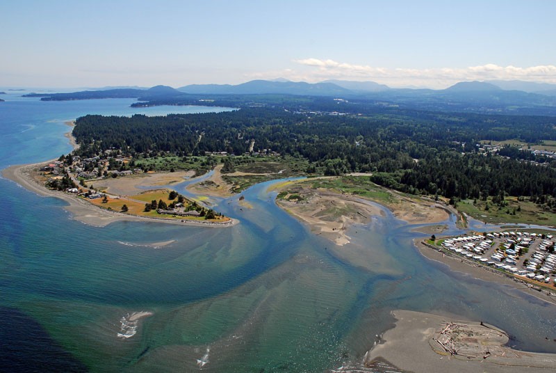
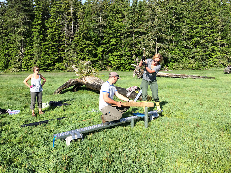
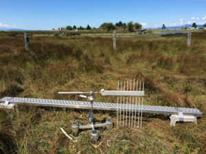
Wed, 26 Apr 2017

Bull River Bighorn Herd Helped by Land Purchase

Bull River property.

The Nature Trust of BC has just announced the successful acquisition of the Bull River Grassland Corridor property in the East Kootenays.


Nature Trust CEO Jasper Lament said the 67 hectare property is an exciting addition to existing conservation lands in the lower Bull River: “Bighorn sheep use this property as part of their traditional winter range,” said Lament. “Because it is bounded on three sides by other conservation lands, it is a very strategically important acquisition.”? The securement of this property removes threats of disease transmission from domestic livestock to the Bull River bighorn sheep herd. It also protects winter range for elk and deer, and protects habitat for the provincially Redlisted American Badger. This project was completed with incredible support from the Habitat Conservation Trust Foundation, BC Conservation Foundation, Fish & Wildlife Compensation Program, and Environment and Climate Change Canada through the Natural Areas Conservation Program facilitated by the Nature Conservancy of Canada. The Habitat Conservation Trust Foundation provided over $350,000 to the purchase of this property, and is also funding a project studying the health and movements of the Bull River bighorn herd. “The Bull River herd has partially recovered from a die-off in the 1980s, and we felt it was critical that this key piece of their winter range was protected from any type of development that could be detrimental to the herd’s survival,” said HCTF CEO Brian Springinotic.

The Bull River bighorn herd in winter.

Each year, HCTF provides approximately half a million dollars to BC conservation organizations purchasing land to protect wildlife habitat. The Foundation also provides over $6M in grants annually for projects benefitting fish and wildlife in BC.

Thu, 3 Nov 2016
Tags: Education

A Summer with the Birds – Student Shares Her Experiences Working with the Delta Farmland and Wildlife Trust

Delta-sunrise.jpg

As a follow-up to our video series on the HCTF Summer Internship Program, we received the following article from the Delta Farmland and Wildlife Trust (DFWT), written by their 2016 intern, Jennifer Sibbald. Jennifer is the third BCIT student to complete a summer internship with DFWT under this program.

Each morning, from May through July, I was up with the sunrise. It wasn’t that I had trouble sleeping or because I’m naturally an early-riser: I was there for the birds.

In spring, as migrating songbirds travel toward their food-rich breeding grounds, many stop in the productive agricultural lands of Delta, BC. This stop-over results in a flurry of morning activity, known by many as the ‘dawn chorus’. This musical cacophony is the sound of many male birds singing to attract a mate, each with their own unique song. In the birding world, these moments are the perfect time to survey birds, as one can identify them by sight as well as sound.

Delta-sunrise.jpg

Though waking at dawn may not be for everyone, it was the perfect way for me to spend a summer. As a student in the Ecological Restoration Program at British Columbia Institute of Technology (BCIT), I jumped at the offer of an internship with Delta Farmland and Wildlife Trust (DF&WT). With generous funding from Habitat Conservation Trust Foundation (HCTF), the City of Surrey, BCIT Rivers Institute, and DF&WT, an internship was created to study the richness (number of species), abundance (number of individuals) and diversity of songbirds using hedgerows planted by DF&WT in Delta, B.C.

In Europe, it is well studied and understood that hedgerows provide many ecological and economic benefits to agricultural landscapes. Hedgerows provide shade for livestock, help reduce soil erosion, give homes to beneficial pollinating insects, and provide necessary breeding habitat for many species of songbirds. DF&WT has long recognized the importance of hedgerow habitats, and has sought to create more of these areas through their ‘ Hedgerow Stewardship Program’. In recent years, DF&WT is initiating some of the first hedgerow studies that I am aware of in British Columbia, including the songbird study I was given the opportunity to be a part of.

Jennifer_S_selfie.jpgIn the spring of 2015, BCIT Ecological Restoration student Arthur Kujawiak began the pilot study focusing on the abundance and diversity of songbirds using DF&WT hedgerows. In 2016, I continued the study to establish a multi-year dataset of the birds using these hedgerows. Additionally, I was empowered by DF&WT to expand the study and ask a few questions of my own. I focused my questioning on whether differences in plant composition of the hedgerows impacted bird communities.

Having been recently immersed in school and ecological theory, I knew that increases in the diversity of plant structure (e.g., different heights) and composition (e.g., different species) typically lead to the increased biodiversity of animals living in an ecosystem. I hypothesized that in hedgerows where plant diversity is greater, we would see a greater diversity of songbirds. From careful study design, data collection, and data summarizing, we found this to be true of DF&WT hedgerows. These findings support the management actions of DF&WT, which strive to plant a diversity of native trees and shrubs along their hedgerows.

After many sunrises, countless hours of data entry, and time spent just listening to the birds, I was able to provide some insight into how songbirds use hedgerows in Delta, BC. As a student, this was a fantastic opportunity ask questions of my own, independently conduct fieldwork, and learn to identify over fifty species of birds by sight and sound! Thanks to the support from DF&WT, HCTF, City of Surrey, and the BCIT Rivers Institute, I have gained invaluable experience for my future as a biologist, and had a summer I will never forget.

A big thank you to Jennifer for sharing her experience with the internship program!

Wed, 26 Oct 2016
Tags: Wildlife

HCTF Visits the Cariboo

Project leaders Jim Young (far right), Ordell Steen (second from right) and their work crew pose for a photo with HCTF Biologist Kathryn Martell.

As part of our evaluation program to ensure HCTF funds are benefiting fish and wildlife conservation, HCTF staff regularly visit project leaders to get an in-depth look at their projects – both on paper (financials) and on the ground.

In late September HCTF staff biologist Kathryn Martell and financial officer Katelynn Sander travelled to Williams Lake to conduct evaluations on two projects. The first was the Fisher Artificial Reproductive Den Box Study led by Larry Davis of Davis Environmental Ltd.

Fishers are a threatened species in British Columbia and are also the largest obligate tree-cavity user in North America. They typically use cavities in large diameter trees both for resting in winter, and as reproductive dens. Suitable den trees are rare in the landscape and impacts in many areas of the province have further reduced the availability of this habitat feature. Larry’s project seeks to determine if fishers will use artificial (man-made) den boxes for reproductive dens, as a way to augment denning habitat in areas where natural den trees have been reduced.

This year of the study continued the monitoring efforts on the 56 den boxes installed during this project. Larry has been successful in attracting fishers to 50% of the den boxes, using them for resting, and more den boxes are being used for reproduction each year.

Biologist Larry Davis readies the ladder for inspection of one of the den boxes.

HCTF Finance Officer Katelynn Sander peers into the den box.

Nothing inside this one...

Close-up of the exterior of the den box.

HCTF biologist Kathryn Martell and Larry Davis pose for a photo after putting the ladder away.

The second project staff explored was the High Lake Grassland and Open Forest Restoration Pilot, led by the Friends of Churn Creek Protected Area Society. The goal of this project is to restore approximately 80 ha of mixed open grassland and dry, open forest habitats which have been degraded by tree encroachment and ingrowth in Churn Creek Protected Area (CCPA). The project is also designed as a pilot to evaluate an approach for encroachment and ingrowth removal that does not require broadcast burning. Logistical constraints restrict using broadcast burning in High Lake and other parts of CCPA, and many of the young trees are already too large to be killed using this technique. Rather, in this pilot, stems are slashed and piled and the piles burned in winter.

Churn_Creek_view.jpg

The project area is within important mule deer range and is located on a designated no-grazing benchmark within the CCPA. Fixed plots have been established to document pre-treatment tree cover, undergrowth vegetation, and mule deer use and measure changes following restoration treatments. Much of the tree encroachment and ingrowth on the project area consists of relatively large (> 4 m tall), often dense (closed or moderately closed canopy) stems.

Tree encroachment was felled and piled by a Stswecem’c-Xgat’tem First Nation crew. Felling on 51 ha (72%) of the encroached grasslands was completed in the summer of 2015, and they were nearly finished when the HCTF team visited in September 2016. Burning the piles is set to take place this winter. You can already see a dramatic difference on this landscape as encroachment areas are being opened up and restored to dry grassland and open forest. This piloted approach has the potential for significant habitat enhancement, in the Churn Creek Protected Area and elsewhere.

Katelynn stands next to a pile of slashed trees that will be burned in winter.

The slashing helps open up the grasslands, mimicking the historical fire regime and improving habitat for wildlife.


HCTF would like to extend a big thank you to the Friends of Churn Creek Protected Area Society, the Stswecem’c-Xgat’tem First Nation crew, and Larry Davis for taking the time to explain the projects and show HCTF around their sites. We were impressed with how well managed and implemented both projects were, and it was great to meet the passionate individuals who are making this happen.

Wed, 31 Aug 2016

Monitoring Vancouver Island Estuaries

Installing-SET-Platform_Cluxewe_July2016

Thanks to Karen Barry from the VICLMP program for sending us this project update!

The Vancouver Island Conservation Land Management Program* has initiated a long term monitoring program to assess the health of estuaries and salt marshes on the east coast of Vancouver Island with support from HCTF and other partners. The goal of this monitoring program is to ensure that conservation lands provide high quality, accessible habitat for fish and wildlife, and to identify conservation concerns resulting from threats such as sea level rise, invasive species, or other human-induced changes. By implementing a standardized monitoring program, we can ensure investments made towards protection of sensitive estuaries are secured for the long-term.

To determine the resiliency of coastal estuaries to sea level rise, we are installing Surface Elevation Tables (SET) platforms in several estuaries this summer, including Quatse River, Cluxewe River, Salmon River, Englishman River, Nanaimo River and Cowichan River estuaries. These devices allow us to see how salt marshes and estuaries are changing over time, by measuring changes in elevation of the substrate. The SET consists of an aluminum platform that is permanently installed in the estuary and anchored to prevent any movement. To take measurements, a specialized reader arm is brought out to the estuary, mounted to the platform and several rods are lowered from the arm onto the surface. Because the location and orientation of the device is fixed during sampling, we can record highly precise elevation measurements. Annual fine-scale readings are compared over time to see how much deposition or erosion is occurring.

When measurements indicate a positive change in elevation, it means that sediment is being deposited, the plants are healthy and stabilizing the sediments, and the underlying marsh soils are getting thicker (accreting). This is a natural process in healthy salt marshes which increases the resiliency of estuaries to rising sea levels. In contrast, negative readings indicate decreasing elevation which means that the marsh surface is sinking (subsiding) or eroding. When the rate of sediment deposition (or accretion) does not match or exceed the rate of subsidence or sea level rise, the salt marsh can eventually “drown” meaning that it becomes sub-tidal. This can result in significant habitat changes for fish and wildlife; for example, vegetated salt marshes can become unvegetated mud flats.

Results from our SET measurements will provide important information about local ecosystem change that can help inform management. Specifically, we will gain a better understanding of whether our estuaries are resilient over the long term, what habitats may be most vulnerable to sea level rise, and what potential restoration actions may be warranted to maintain or improve fish and wildlife habitat.

* The Vancouver Island Conservation Land Management Program (VICLMP) is a strategic partnership program with Environment Canada-Canadian Wildlife Service, the Ministry of Forests, Lands and Natural Resource Operations, Ducks Unlimited Canada, The Nature Trust of British Columbia, and funding from Habitat Conservation Trust Foundation. VICLMP’s work focuses on managing over 100 conservation areas on Vancouver Island and the central and north coasts.

Wed, 31 Aug 2016
Tags: Education

Transformed School Grounds Enhance Environmental Learning


Nestled in the heart of the Fraser Valley lies the small rural community of Dewdney. Three years ago, declining enrollment threatened the future of the community’s only school, but today, Dewdney Elementary has become a shining example of how re-creating outdoor space can strengthen student learning and bring together a community. Led by the vision of their Principal, Mrs. McLeod, and the implementation of the Community Outdoor Recreation and Environmental Education (CORE) program, this small school has been hugely successful in incorporating environmental education, stewardship and restoration into everyday learning.


The school transformed a soggy field of grass into a naturalized area full of opportunities for play, growth and learning. Students participated in the design and construction of various features, including a “mud kitchen” and garden boxes for growing food. They also planted and cared for fruit trees, edible berry bushes and other native plants. A wooden tree-cookie pathway leads the young learners through the landscape, past apple trees and strawberry plantings into a free play area with loose natural materials for making whatever the students can imagine come to life. Not without modern conveniences, the site also boasts rainwater harvesting, biofiltration swales, and a power-generating windmill for a covered shelter appropriately named “the Den”.


Dewdney_elementary_tree_cookie_path.jpg

Teachers at Dewdney have used the concepts from HCTF’s Wild Schools and the Get Outdoors resources to augment the student’s use of the learning area during free time, as well as more deeply infusing it into the learning process while doing inquiry based work and while planting and maintaining the planter boxes. Using a GO Grant, classes were able to create and nurture food gardens including a three-sisters planting concept of beans, corn and squash . In the fall, they will harvest, prepare and preserve their garden’s bounty with the help of community partners.

Experiences in the outdoor space integrate curriculum concepts of numeracy, language, science and physical education. Students learn from their successes and also failures; they’ve witnessed some of their gardening work quickly undone by nighttime critters, and gained an understanding of the interactions between plants and wildlife in the process. Seeds that fail to sprout prompt questions as to why, providing an opportunity for inquiry-based learning. These experiences are only the beginning; Dewdney’s efforts to integrate ecology and stewardship into student learning recently won them $25,000 of technology from Staples to help further their environmental and educational programs. These include restoring and expanding a wetland are covered in invasive reed canary plants and the addition of a large greenhouse.

While replicating the success of Dewdney Elementary’s schoolyard transformation may seem daunting to those starting with a blank schoolyard canvas, Dewdney’s administration encourages interested schools to start small and build as you grow. “Our project and any successes that come along with it, are the result of teachers, parents, community members, businesses working together to make a difference in their corner of the world,” says Sue McLeod, the school’s principal. “It is not the size of the project that is important, but the willingness to jump in and get their hands dirty. That is the most fun of all!”


Thanks to WildBC facilitator Lisa Fox for sharing this story with us! For more information on HCTF Education’s projects and programs, visit hctfeducation.ca

UPDATE: Read about how Dewdney Elementary School is making their school yard even greener through the HCTF-funded Wetlands Institute.


Wed, 24 Aug 2016
Tags: Fisheries

Rock Breaking Begins at Seymour Slide Site

Aerial photo of the Seymour River rockslide. Photo credit: Taylor Ramsden

The Seymour Salmonid Society and its partners are pleased to announce that work has begun to restore fish migration around the rockslide debris that has blocked the Seymour River for over 20 months.

On December 7, 2014, an estimated 50 000 cubic meters of rock fell into the lower canyon of the Seymour River following a catastrophic slope failure. The slide debris blocked the river and caused upstream water levels to rise by almost 10 meters. Acoustic and radio tagging studies have confirmed that the blockage has prevented both adult and juvenile salmon from accessing their primary spawning habitats upstream, creating serious concerns about the survival of salmonids on the Seymour. The river is home to unique runs of wild summer and winter steelhead, currently listed by the Province as a conservation concern. Coho, chinook, chum and pink salmon also use the river as spawning and rearing habitat.


Shaun Hollingsworth, President of the Seymour Salmonid Society, emphasized the effects the blockage will have on the river’s fish populations if left unmitigated: “If these fish remain cut off from their spawning habitats, the Seymour’s wild steelhead and coho populations will likely be reduced to mere remnants within five years. The summer-run steelhead may ultimately disappear,” says Hollingsworth. “We must do whatever needs to be done to save these fish.”

Fisheries and Oceans Canada’s Salmonid Enhancement Program, the BC Ministry of Forests, Lands and Natural Resource Operations, Metro Vancouver, the District of North Vancouver, Squamish Nation and Tsleil-Waututh Nation Bands have all agreed in principle to begin re-shaping the slide using scaling crews, low-velocity rock breaking, and river flows as part of a shared vision to “restore migration conditions for all species that existed before the 2014 rockslide, in a safe and sustainable manner.”

Funding for the reshaping has been provided by the Habitat Conservation Trust Foundation, Freshwater Fisheries Society of BC, the Ministry of Forest, Lands and Natural Resource Operations, Tsleil-Waututh Nation, Squamish Nation, the Recreational Conservation Partnership Program, the Department of fisheries and Oceans, both the District and the City of North Vancouver, Coho Society of BC, Steelhead Society of BC, BC Federation of Drift Fishers, and multiple private donations.

The Seymour Salmonid Society is a community based organization consisting of volunteers whose mission is to enhance Seymour River salmon and educate the public about the importance of the river as a resource for drinking water, wildlife, and the forest. For more information, contact Brian Smith, Seymour Salmonid Society Hatchery Manager on 604 288-0511. To join the community volunteers, or donate, please visit www.seymoursalmon.com


PDF Version of Release

Photos (please contact us for larger versions of these images)


Credit Simon Ager

Credit Taylor Ramsden


An engineer marks drilling locations in preparation for Wednesday's rock breaking on the Seymour River.


Read the story in the North Shore News >>