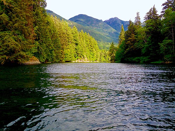
Thu, 20 Nov 2014
Tags: Wildlife

Declining Den Sites: Finding Cavities Fit for a Fisher

Photograph of Fisher by Larry Davis

What’s furry, fierce and likes to dine on porcupine? It’s the fisher, Pekania pennanti, a member of the weasel family that is seldom seen in the wild, but is an important part of British Columbia’s carnivore community. Despite its name, fishers do not fish and are dependent on forests for all their life history needs. The fisher is blue-listed (threatened) in BC, largely due to habitat loss. Female fishers require large diameter trees with cavities to birth and raise their young. They will only use cavities with entrance holes that are approximately 8 – 12 cm in diameter: large enough for them to squeeze into, but small enough to keep larger predators away from their kits. Den trees also need to have other trees and shrubs around them to allow the female approach her den unseen. These specific requirements (along with the fact that females usually require multiple cavities to accommodate the growing kits) make fisher populations extremely vulnerable to extirpation through loss of suitable denning habitat.


In the Bridge River Watershed, north of Lillooet, BC, fisher habitat has been impacted by the creation of two large hydro-electric reservoirs, large-scale fires, mountain pine beetle, and an ongoing history of forest harvesting that is dominated by clear-cut systems. Understandably, there is concern about the combination of these habitat impacts on local fisher populations.

The Habitat Conservation Trust Foundation and BC Hydro funded a three-year project that would provide an accurate population estimate for fishers in the Bridge River watershed, as well as estimate the distribution, abundance, and supply of potential reproductive dens. In-kind support for this research was provided by the Lillooet Tribal Council, BC Ministry of Environment, and the BC Trappers Association.

Estimating Fisher Density

Fisher expert Larry Davis and his research team determined fisher density estimates using a winter hair snag survey. Davis explains: “We used sticky mousetrap paper to pull a sample of hairs from fishers that were attracted to traps baited with a chicken wing. Fishers trying to get the wing would press against the mousetrap paper and leave a hair sample behind for us to collect. We sent the samples to a laboratory specializing in wildlife genetics that identified the samples by species, sex, and individual identity.”

“Of course, we captured many other animals that went after the bait,” Davis continues. “We even had one wolverine chew the top half of the trap off.”

In the end, Davis and his team were able to identify 8 different fishers from the data, some of which were captured multiple times. The data was inputted into a computer program that used this information to estimate that there were 14 fishers in the 771-km2 study area. This yields an estimate of 18 fishers per 1000 km2: relatively abundant when compared to estimates from elsewhere in BC.

“It’s important to note that this estimate is based on only one season of sampling and animal numbers can vary considerably between years,” clarifies Davis. “Also, only three of the 8 fishers sampled were females and some are likely to be young from last year’s litter or transient animals. Despite this caveat, Davis believes that “the Bridge River area supports a healthy population of fishers, and that a sustainable population can be maintained if important habitats, such as den sites, are retained in managed forests”

Fisher_head_in_cavity.jpgEstimating Available Denning Sites

To estimate the number of trees that would make suitable fisher den sites, Davis concentrated on areas where track transects had found fisher. Potential fisher den trees were identified as those meeting the following criteria:

  • right species;
  • large diameter stems; and
  • the presence of a heart-rot decay cavity with an entrance hole 8 – 12 cm in size.

The “right species” criterion was based on previous research that found fishers using cottonwood, balsam poplar, trembling aspen, Douglas-fir, and lodgepole pine as den trees in BC. Common to these tree species is that they can have extensive heart-rot forming large internal cavities while the tree is still living. Other trees, such as spruce, also get heart-rot, but don’t maintain the hard exterior shell that preserves the standing tree and cavity for many years. The minimum tree diameter depends on the tree type, but is generally large for the particular tree species.

Davis and his team estimated the number of potential trees in the landscape by counting the number found in 1 hectare transects distributed across the study area.

“It turns out that trees meeting all our criteria are rare in the landscape,” says Davis. “Even in the ‘best’ habitat, there was less than 1 tree in 2 ha, and most forest types had much lower densities of potential den trees.” As Larry explains, the actual densities may be even lower still: “There is one additional criterion a fisher would have that we couldn’t easily check – the size of internal cavities. Cavities large enough for a female fisher and her kits are estimated at 25 – 30 cm in diameter, based on the size of an average female and internal measurements we have taken at fisher dens. Given this, fisher reproductive dens are likely to be much scarcer than we think, but our estimate provides a starting place for making recommendations to forest companies on targets for protecting fisher den trees.”

Fisher_Kits_R_Weir.jpgSo how are these findings being used to inform fisher management? These results, combined with the findings of more than 20 years of fisher research in BC, have been used to create management recommendations and targets for fisher habitat. Davis and his colleagues have created a website summarizing this information at www.bcfisherhabitat.ca . For foresters and government, the website supplies targets on the amount of area and number of structures fishers need for breeding, resting, foraging, and movement habitats. This means tenure holders, such as trappers, can use this information to ask foresters how they are meeting fisher targets for logging operations on their trap lines.

“Fishers are a blue-listed species in BC, and forest professionals are legally required to manage landscapes to help maintain this species,” says Davis. “The website allows the BC Fisher Working Group an opportunity to continue working with trappers, government, the forest industry, and others to update and refine management strategies for fisher in a timely fashion.” Davis and his team have also created resources to encourage private landowners to preserve suitable den trees on their land (view). “Preserving these types of trees not only help fishers, it also benefits around many other native species reliant on them for their continued survival.”

Many thanks to Larry Davis for supplying much of the information and images for this article. In recognition of the fact that studies like this one indicate suitable fisher denning habitats are becoming increasingly rare, HCTF is currently funding a project to determine if artificial den boxes will be used by reproductive fishers, and the extent to which these devices might mitigate the loss of natural denning habitat. Check back here for future updates on this project.

Did you know?

The scientific name for fishers was formerly Martes pennanti, putting them in the same genus as marten. Fishers recently acquired a new scientific moniker as a result of DNA analysis proving that (despite appearances) they are actually more closely related to wolverines (Gulo gulo) than martens, but still distinct enough to warrant a separate genus, hence, Pekania pennanti. Discoveries like this are great examples of how we still have a lot to learn about wildlife, even those species in our own backyard!

View updates about this project>>

Thu, 13 Nov 2014
Tags: Wildlife

Tiny Technology: Mapping Marten Movement

A marten recovers after being fitted with a GPS collar. Animals are anesthetized using isoflurane, as it is quickly expelled from the system. They have fully recovered by the time they are released back into the wild. Photo Credit: Willa Crowley

In the frozen wilderness of North-central BC, a small, furry head pops out from under the snow. Its fox-like profile stands out against a creamy orange bib of fur. In a flash, the animal’s long, lithe body and bushy tail spring from the powder. It is an American Marten (Martes americana), a medium-sized mustelid known for its tree-top acrobatics and cat-like curiousity. She boldly lopes across the snow towards a tasty morsel, conspicuously placed to entice her into a cage trap disguised with branches and straw. Marten are commonly trapped for their pelts, but this cage won’t spell her demise. Instead, she will become part of a ground-breaking study examining marten’s movements, and how they might be affected by forestry practices.

Shannon Crowley, a researcher with the John Prince Research Forest (co-managed by UNBC and T’laz’ten Nation), and his colleagues check the study traps daily: if they’re lucky enough to get a marten, they fit it with the latest in GPS collars before releasing it safely back into the forest.

“They’re tough little critters,” confides Crowley. “Based on our experiences capturing them, they’re not fearful at all. We’ve had marten in cage traps that we’ve released, only to have them come back moments later to steal a piece of bait sitting right next to us.”

Crowley and his colleagues are working on their second year of an HCTF-funded project to determine how marten populations are affected by salvage logging of Mountain Pine Beetle-ravaged stands. They are comparing the species’ use of logged and unlogged areas by remotely tracking the movements of their collared subjects.

“We’re working with very new technology,” explains Crowley. “Really, this study is pioneering the use of GPS collars light enough to go on an animal this size. To my knowledge, we and a group in Scotland are the only ones to have tried them on marten.”

Marten_recovery_HCTF_7-412_credit_Willa-Crowley.jpg

The general rule of thumb for tracking collars is that they shouldn’t exceed 5% of an animal’s body weight. The collars used by Crowley and his team are below that threshold, sitting at around 3%.

“The marten really don’t seem to be bothered by them,” says Crowley. “We happened to get a video of one of the collared animals at one of our remote camera sites, and he was heading up into the trees, behaving very much like a typical marten.”


Above: Video showing typical marten behaviour. These curious creatures often travel under the snowpack, but are equally adept at climbing trees. See more videos of marten and other mesocarnivores filmed in the John Prince Research Forest at the end of this post.

Crowley says the location data from the new GPS collars is a significant improvement over what they could previously obtain using radio units.

“We’re pretty impressed: we’re getting the kind of movement data that we could have never gotten in the past,” says Crowley. “Getting a location used to be very labour intensive, especially in harsh winter conditions. We would typically get about three locations a week. Now, we’re averaging between six and twelve locations a day.”

The increased amounts of data allow Crowley and his team to examine how marten are moving across the landscape at a much finer scale. “Previously, we could see where they were, but we couldn’t see how they got there. Now, we have a clearer picture of how they’re using different habitat types.”

Crowley’s team has been working closely with local forest company Conifex to compare martens’ response to different logging practices. Eventually, their results could be used to inform forest management decisions so as to reduce the impact on marten, as well as other species.

“Marten have proven to be really good indicators of ecosystem health,” emphasizes Crowley. “They’re generally associated with mature forests with lots of structural complexity, which are also important for animals such as woodpeckers and mule deer.”

Though Crowley’s marten study is a short-term project, the data collected will become an important component of a long-term monitoring program focused on mesocarnivores, a group that also includes fishers, river otters, foxes and Canada lynx.

“The mesocarnivores encompass a diversity of species that require different habitat types,” explains Crowley. “Studying one species alone can tell you something, but when you look at a bunch of them together, by inventorying and surveying in different habitats, they can give you a much better idea of what’s happening on the landscape.”

This level of understanding is particularly important when considering the rapid rate of environmental change associated with salvage logging. Though marten populations as a whole are thought to be stable in BC, they have become endangered or even extirpated from other jurisdictions through habitat loss.

“Research like this is really about taking preventative action, so that marten don’t become endangered in BC as a result of land use practices.” Crowley states.

Despite the economic pressures to maximize timber harvest, Crowley remains optimistic about the potential for this research to make a positive difference for habitat conservation. “Within the forestry industry, I think there’s definitely an appetite for finding ways to reduce impacts. Wildlife and habitat have definitely become part of the conversation, though we still have a long way to go before wildlife values are incorporated as a standard practice.”


The John Prince Research Forest is the largest research forest in North America, more than 32 times the size of Vancouver’s Stanley Park. Situated 50 km north of Fort St. James, the JPRF lies between Lakes Chuzghun (Tezzeron) and Tesgha (Pinchi)in traditional Tl’azt’en territory and provides research opportunities for UNBC staff and students and education and employment opportunities for the local community. Check out some of the other amazing wildlife footage captured by remote cameras in the forest (submitted to us by Shannon Crowley):


American Marten:

Canada Lynx:


Wolverine:

Mon, 20 Oct 2014

Historic Grasslands Conserved

Last Friday, HCTF Board member Ian McGregor joined the Nature Conservancy of Canada (NCC) in Kamloops to celebrate the successful acquisition of 525 hectares of native grassland in the Nicola Valley. HCTF contributed a quarter of a million dollars to the Napier Lake Ranch project, which will protect habitat for migratory birds, rare grassland plants and mammals such as moose and mule deer.

“Like all of HCTF’s acquisition investments, Napier Lake Ranch was funded because it contains significant habitat values that were under threat of fragmentation,” said McGregor. “By supporting NCC’s purchase of these lands, we can be assured that grasslands, and the plants and animals that live there, will be protected now and forever. This means future generations may have the opportunity to witness Sharp-tailed grouse, spot a Swainson’s hawk, or hear the sounds of Sandhill cranes rolling across the grasslands.”

Napier_Lake_Grasslands_video.JPG

Long_billed_curlew_in_flight_CC_Alan_Vernon_small.jpgIndeed, both Sharp-tailed grouse and Sandhill cranes were observed by celebration participants on an NCC-led tour of the newly-acquired lands. One of those participants was the land’s former owner, Agnes Jackson. Her family sustainably managed these grasslands for over 40 years, and her decision to sell to the Conservancy was based on her desire to see them remain a haven for many plants and animals.

“Grasslands hold more endangered species than any other climatic zone,” said Jackson. “Keeping large tracts of land intact is really the only way to protect them.”

In a CBC radio interview earlier this year, Jackson spoke about her hope that others would be able to experience these lands and enjoy them as much as she did. NCC plans to allow non-motorized vehicle access to the property, allowing people to further their connection to grassland conservation.

As part of the celebration, NCC acknowledged the many groups who contributed to this project, including the Government of Canada, the Jackson Family, The Sitka Foundation, the Estate of Thomas T. Forbes and HCTF. HCTF funding of this and other recent NCC conservation land acquisitions was made possible through the contributions of the province’s anglers, hunters, trappers and guides, whose licence surcharges provide approximately $6 Million for conservation projects annually. To find out more about the different types of projects HCTF supports, including conservation land acquisitions, click here.


Tue, 7 Oct 2014
Tags: PCAF

Garnet Valley Wildlife Habitat Protected

Garnet_Valley_restoration_PCAF.jpg

This past week, volunteers from the Summerland Sportsmen’s Association worked alongside the Provincial Conservation Officer Service and the South Okanagan Similkameen Conservation Program in Garnet Valley between Summerland and Peachland, posting new motorized vehicle regulations and restrictions signs as well as marking and deactivating illegal trails.

Garnet Valley has some of the Okanagan’s most valuable wildlife habitat, with south-facing slopes ideal for winter and early spring habitat for mule deer. The valley is a beautifully diverse landscape – with sensitive wetlands, grasslands, rugged terrain and open forests. It’s a link for wildlife to move and connect to other important natural areas away from the busy Hwy 97 corridor.

With the support of HCTF in the 1980’s, the Province of BC recognized the importance of the Garnet area and purchased a number of private parcels to augment crown land holdings. A significant increase in motorized vehicle damage and illegal trail building over the years has markedly degraded the habitat and resulted in disturbance to mule deer on their winter range.

In early 2014, the Province of BC established new Motor Vehicle Prohibition Regulations under the Wildlife Act for Garnet Valley to protect the values. The new regulations for Garnet Valley designate open legal routes and closed illegal routes to protect wildlife and allow habitat to recover. Leading up to the closure, BC Conservation Officers and Forestry Compliance and Enforcement Officers had been providing education and information about the coming changes to the motorized recreation community – now it was time for full implementation.

The partnerships forged during a successful PCAF project in 2012 came together once again with the Summerland Sportsmen’s Association, South Okanagan Similkameen Conservation Program and the BC Conservation Officer Service working side by side to assist in the protection of Garnet Valley wildlife habitat. With funding provided by the HCTF Public Conservation Assistance Fund 2014 and in-kind matched by the partners, vehicle closure project was completed during the last week of September. Volunteers and government staff systematically marked the open and seasonally open routes, while marking and deactivating the illegal routes over a number of blue bird fall days. A flat tire on the backhoe was the only hitch in an otherwise seamless project supervised by Sargent Jim Beck of the BC Conservation Officer Service.

Garnet_Valley_sign_installation.jpg“The success of our last PCAF project has inspired all of us, the sportsmen’s club, the conservation partnership and the provincial government to keep working together for habitat recovery in the Garnet”, said Bryn White, SOSCP Program Manager. In 2012, HCTF’s PCAF program supported an application from the groups to fence one of the last wetlands in the valley called Ritchie Lake that had been significantly degraded by mud-bogging off road vehicles and cattle. In one year after the wildlife-friendly fence was built, the dry rutted area was unrecognizable. In its place was a beautiful and lush wetland complete with reeds, dragonflies and ducks. This year, the group took some time to sit and have lunch at Ritchie Lake to enjoy the view. It wasn’t long before talk of another damaged wetland area seen in the north end of Garnet Valley came up that would benefit from excluding cattle and mud-bogging off road vehicles. McLachlan Lake looks very similar to Ritchie Lake – pre-fence. It is holding water for the first time in a number of years, and would be a perfect joint project given its location between the Summerland and Peachland Sportsmen’s Club. Stay tuned to hear how they tackle this one.


Our thanks to the South-Okanagan Similkameen Conservation Program for providing this update on PCAF Project #1032.

Fri, 19 Sep 2014
Tags: Wildlife

Out of the Ashes

Each spring, BC’s fire crews brace themselves for the intensity of the fire season ahead. At the time of writing, 2014 was on track to become a record year. Since the beginning of the season in April, more than 330,000 hectares had burned, only ~8,000 HA shy of the 30 year record. News coverage of evacuations and threats to human infrastructure have shaped our perception of forest fires. We think of them as catastrophic forces of destruction: unpredictable disasters to be suppressed or extinguished at all costs.

There is, however, another side to forest fires, one that would suggest this year’s increased fire activity – if kept away from human settlement and infrastructure – is actually beneficial. Ecologists have confirmed empirically what First Nations have known and practiced for centuries: fire is as much a force for renewal as it is of destruction.

After a forest fire, what appears as scorched wasteland is actually an ecosystem ready to begin anew. Under the charred earth, roots and seeds lie waiting to capitalize on the nutrients provided by the ashes of their predecessors. Sunlight, once scarce under the thick canopy of mature trees, now reaches the ground, allowing grasses and berry-producing shrubs to flourish. Burned trees still standing provide habitat for many species of insects and birds. Fire is nature’s own highly effective method of ecological restoration.

Block_22_on_fire.jpgWe live in a province shaped by fire; the plants and associated animals found in a particular location are a product of that area’s fire regime. Before the introduction of modern fire-suppression techniques, scientists estimate that around 500,000 hectares of forest burned in BC each year, a figure that dwarfs the sum of even the most prolific fire seasons of recent years. Just as fire shaped BC’s landscape, an absence of fire is shifting it again. In the many areas where the natural fire cycle has been interrupted, trees have invaded grasslands, forcing wildlife to look elsewhere for forage. Fuel, in the form of dead wood and debris, has built up on forest floors, creating the potential for more intense, more dangerous fire events than would have occurred under the natural fire regime. Perhaps one of the most graphic unintended consequences of fire suppression is the Mountain Pine Beetle epidemic. Historically, areas of pine forests would have burned down and regenerated roughly once every 100 years, resulting in multi-aged forests that were more resistant to insects and disease. Modern fire suppression has led to vast, interconnected stands of old pines- a favourite food of the beetle. Add to this increased temperatures that allow the beetle to survive through the winter, and you have the worst insect epidemic in BC’s history.

Jordy McAuley has witnessed first-hand the effects of fire suppression on lands where burning was once an integral part of the forest lifecycle. His outfitting territory in the Williston area of BC includes large stands of mature aspen and pine-beetle affected forest. The encroachment of trees on previously open areas, combined with flooding caused by the creation of the Williston reservoir, has severely reduced the amount of winter range available for ungulates such as moose. They have begun to travel beyond their traditional range to higher elevations. With them come the wolves, and that’s bad news for the caribou who overwinter there.

“The caribou are easy targets… they’re really struggling,” says McAuley. “If we can improve range conditions for moose and other ungulates at elevations lower than where the caribou are, it would hopefully lure the predators away and give them a chance.”

Since purchasing the territory nine years ago, McAuley has been keen to bring fire back to the landscape after witnessing the improvements to range conditions following prescribed burns in other regions.

Block_22_Understory_Before_burning.jpg“Once you burn, everything comes back new,” McAuley says. “The canopy opens up, and there’s this rejuvenation of forage for all kinds of wildlife. Moose do well, same with elk and goats. The berries come back, providing food for bears – even birds seem to benefit.”

McAuley’s observations are consistent with research showing increased species use of habitats after burning. Properly executed, prescribed burns create a mosaic of habitat types that can support an increased number of species, and provide the resources necessary to sustain their populations. Indeed, the broad scale restorative properties of prescribed burning make it an attractive land management tool, but conducting burns is expensive, and some of the Province’s burn programs are reliant on external funding. Using hunting licence surcharge revenue, the Habitat Conservation Trust Foundation (HCTF) has supported prescribed fire projects, such as the Peace-Liard Burns, for thirty years. In 2014-15, the Foundation invested over $350K in prescribed burning programs across BC, including McAuley’s moose habitat enhancement project.

With funding for his project secured, McAuley began working with a team of biologists on the burn planning and consultation process. In an era of multiple (and often competing) uses on the landscape, accommodating the perspectives of all stakeholders can be a difficult task. It’s a delicate balancing act between protecting everyone’s interests and still accomplishing an effective burn. Biologist and Wildlife Infometrics’ staff member Stephanie Rooke agrees that the burn approval process can be daunting.

“There are many, many factors to consider, and some real constraints on what we’re able to do,” says Rooke. “Often, the lands we’re working on are next to forestry plantations, and there are First Nations communities nearby… safety is always our number one concern. We can’t afford to lose a fire.”

Rooke says there are a number of precautions that are used to make sure that burns stay in control and away from human settlements. “The Wildfire Management Branch has indices that we use to determine when it is safe to burn: factors such as temperature, moisture, and relative humidity all have to line up before we’ll start a fire. But our biggest control mechanism for spring burns is high-elevation snow load: because we’re burning uphill, we try to have the edge of where we want burned bordered by snowpack.”

Despite challenges in the planning process and narrow windows for burns, the project team persevered and managed to get their first burn done this May. McAuley was on site for the big event, excited to finally see his idea become reality.

“It was such a big build up: in the beginning, it was like running into walls. I’d tell people what I wanted to do, but with all the merchantable timber up here, they’d say it can’t be done. But I just kept pecking away, and found some folks that knew the benefits of fire on the land,” recounts McAuley. “To see that helicopter show up, ready to go… well, it was pretty exciting to see that smoke start coming out of the bush”

a1sx2_Original1_Moose_HCTF_Meeting.jpgOver the next few years, the project team will monitor this and other planned burn sites to determine what effect fire has had on forage availability and use by ungulates.

“Our hope is that the herbaceous plants and shrubs that recolonize burned areas really make a difference for moose populations in the area,” says Rooke. “Shrubs are particularly important in winter, when the deep snow makes it difficult for moose to access other forage.”

If the project proves a success, the team is hopeful they can share their experiences with others interested in using fire to enhance range conditions.

“There was a steep learning curve for everyone, but now that we’ve done it, I think there’s the potential for others to follow in our footsteps, and maybe initiate their own projects,” encourages McAuley. “I think getting fire back on the land, when done properly, has the potential to benefit everyone.”

In addition to HCTF funding, this project also received financial support from the Peace/Williston Fish and Wildlife Compensation Program. For more information on projects made possible by angling, hunting, guiding and trapping licence surcharges, click here.

Thu, 28 Aug 2014
Tags: Fisheries

Shaping up Seymour

Seymour estuary restoration earth moving.jpg

is well on its way to being restored to an important transition ground for juvenile seagoing trout, char and salmon making their way out to Burrard Inlet. Major earth moving work for this BIRPP project was completed last week, reshaping and contouring the estuary to make it more hospitable for the fish and other organisms that historically thrived there. Creosote-soaked structures leaking contaminants and invasive plants were removed from the estuary, and huge logs and boulders were strategically placed to both provide cover for young salmonids and to protect the native vegetation that will be planted here next spring. These plantings will complete the site’s transformation from an estuary with virtually no cover or foraging habitat to a functional ecosystem offering multiple benefits to fish, wildlife and humans.


The work at the Seymour River estuary will soon be followed by earth moving at another BIRPP estuary restoration project, Mosquito Creek. This estuary has been reduced to 1% of its historical size through waterfront industrial development. This will be an excellent opportunity to view restoration work in progress, as the site is located at a key junction point for the North Shore Spirit Trail. Check back here in September for more BIRPP project updates.


Seymour_restoration_invasive_removal.jpgSeymour_restoration_BCIT_grads_securing_log.jpg